Modesto geodata
Modesto (California) is a seat of a second-order administrative division; located in United States in America/Los_Angeles (GMT-7) time zone. With population of 211,266 people, there are 114 cities with bigger population in this country. Compared to other cities in United States, 63.5% of cities are located further ↑North; 93.8% of cities are located further →East and 84.8% of cities have higher elevation than Modesto. Note1


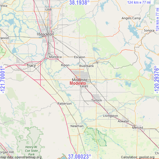
Modesto GPS coordinates[2]
37° 38' 20.76" North, 120° 59' 48.768" West
| Map corner | latitude | longitude |
|---|---|---|
| Upper-left | 38.1938°, | -121.70001° |
| Center: | 37.6391°, | -120.99688° |
| Lower-right: | 37.08023°, | -120.29376° |
| Map W x H: | 123.8×123.8 km | = 76.9×76.9mi |
| max Lat: | 71.29058° ⇑63.5% North |
| Modesto: | 37.6391° |
| min Lat: | ⇓36.5% South 19.06759° |
| min Long | Modesto | max Long |
| -171.73463° | -120.99688° | -66.98998° |
| W 6.2%⇐ | ⇒93.8% E |
Elevation
Elevation of Modesto is 29 m = 95 ft, and this is 265.8 m = 872 ft below average elevation for this country.
| Max E: |
3189 m = 10463 ft | 84.8% |
| Avg. | 294.8 m = 967 ft | |
| Modesto | 29 m = 95 ft | |
Min E: |
-60 m = -197 ft | 15.2% |
See also: Modesto elevation on elevation.city.
Geographical zone
Modesto is located in North temperate zone (between Tropic of Cancer and the Arctic Circle). Distance of this Northern Tropic circle is 1579.2 km =981.3 mi to South.| Distance of | km | miles | from Modesto |
|---|---|---|---|
| North Pole | 5822 | 3617.6 | to North |
| Arctic Circle | 3216.1 | 1998.4 | to North |
| Tropic Cancer | 1579.2 | 981.3 | to South |
| Equator | 4185.1 | 2600.5 | to South |


Nearby cities:
15 places around Modesto: (largest is in red/bold)
• Bret Harte
4.2 km =2.6 mi,  190°
190°
• Bystrom
2.3 km =1.4 mi,  154°
154°
• Ceres
6 km =3.7 mi,  144°
144°
• Del Rio
11.7 km =7.3 mi,  353°
353°
• Empire
8.3 km =5.2 mi,  90°
90°
• Escalon
17.6 km =10.9 mi,  359°
359°
• Grayson
18.1 km =11.2 mi,  242°
242°
• Hughson
12.4 km =7.7 mi,  112°
112°
• Keyes
11.6 km =7.2 mi, 141°
• Ripon
16 km =9.9 mi,  315°
315°
• Riverbank
12.1 km =7.5 mi,  26°
26°
• Riverdale Park
5.9 km =3.7 mi, 235°
• Salida
10.7 km =6.6 mi,  313°
313°
• Shackelford
2.8 km =1.7 mi,  172°
172°
• West Modesto
4.4 km =2.7 mi, 237°
Sources, notices
• [Note1] Compared only with cities in United States existing in our database
• [Src1] Map data: © OpenStreetMap contributors (CC-BY-SA)
• [Src2] Other city data from geonames.org with taken over terms of usage.
• [Src3] Geographical zone / Annual Mean Temperature by Robert A. Rohde @ Wikipedia
