Bret Harte geodata
Bret Harte (California) is a section of populated place; located in United States in America/Los_Angeles (GMT-7) time zone. With population of 5,152 people, there are 7040 cities with bigger population in this country. Compared to other cities in United States, 63.7% of cities are located further ↑North; 93.8% of cities are located further →East and 87.8% of cities have higher elevation than Bret Harte. Note1


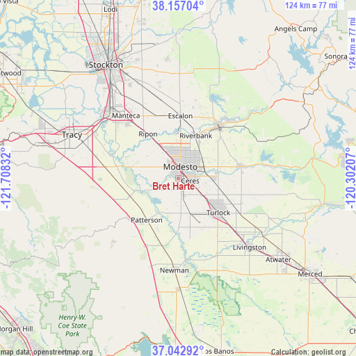
Bret Harte GPS coordinates[2]
37° 36' 7.452" North, 121° 0' 18.684" West
| Map corner | latitude | longitude |
|---|---|---|
| Upper-left | 38.15704°, | -121.70832° |
| Center: | 37.60207°, | -121.00519° |
| Lower-right: | 37.04292°, | -120.30207° |
| Map W x H: | 123.9×123.9 km | = 77×77mi |
| max Lat: | 71.29058° ⇑63.7% North |
| Bret Harte: | 37.60207° |
| min Lat: | ⇓36.3% South 19.06759° |
| min Long | Bret Harte | max Long |
| -171.73463° | -121.00519° | -66.98998° |
| W 6.2%⇐ | ⇒93.8% E |
Elevation
Elevation of Bret Harte is 21 m = 69 ft, and this is 273.8 m = 898 ft below average elevation for this country.
| Max E: |
3189 m = 10463 ft | 87.8% |
| Avg. | 294.8 m = 967 ft | |
| Bret Harte | 21 m = 69 ft | |
Min E: |
-60 m = -197 ft | 12.2% |
See also: United States elevation on elevation.city.
Geographical zone
Bret Harte is located in North temperate zone (between Tropic of Cancer and the Arctic Circle). Distance of this Northern Tropic circle is 1575 km =978.7 mi to South.| Distance of | km | miles | from Bret Harte |
|---|---|---|---|
| North Pole | 5826.1 | 3620.2 | to North |
| Arctic Circle | 3220.2 | 2000.9 | to North |
| Tropic Cancer | 1575 | 978.7 | to South |
| Equator | 4181 | 2598 | to South |


Nearby cities:
15 places around Bret Harte: (largest is in red/bold)
• Bystrom
2.7 km =1.7 mi,  39°
39°
• Ceres
4.3 km =2.7 mi,  100°
100°
• Del Rio
15.7 km =9.8 mi,  357°
357°
• Empire
9.9 km =6.2 mi,  66°
66°
• Grayson
15.9 km =9.9 mi,  254°
254°
• Hughson
12.3 km =7.6 mi,  92°
92°
• Keyes
9.4 km =5.8 mi,  122°
122°
• Modesto
4.2 km =2.6 mi,  10°
10°
• Patterson
18.2 km =11.3 mi,  217°
217°
• Riverbank
16.1 km =10 mi,  22°
22°
• Riverdale Park
4.2 km =2.6 mi,  281°
281°
• Salida
13.5 km =8.4 mi,  328°
328°
• Shackelford
1.7 km =1.1 mi, 40°
• West Modesto
3.4 km =2.1 mi,  299°
299°
• Westley
18.1 km =11.2 mi, 251°
Sources, notices
• [Note1] Compared only with cities in United States existing in our database
• [Src1] Map data: © OpenStreetMap contributors (CC-BY-SA)
• [Src2] Other city data from geonames.org with taken over terms of usage.
• [Src3] Geographical zone / Annual Mean Temperature by Robert A. Rohde @ Wikipedia
