Eucalyptus Hills geodata
Eucalyptus Hills (California) is a populated place; located in United States in America/Los_Angeles (GMT-7) time zone. With population of 5,313 people, there are 6901 cities with bigger population in this country. Compared to other cities in United States, 85.6% of cities are located further ↑North; 89.7% of cities are located further →East and 50.7% of cities have lower elevation than Eucalyptus Hills. Note1


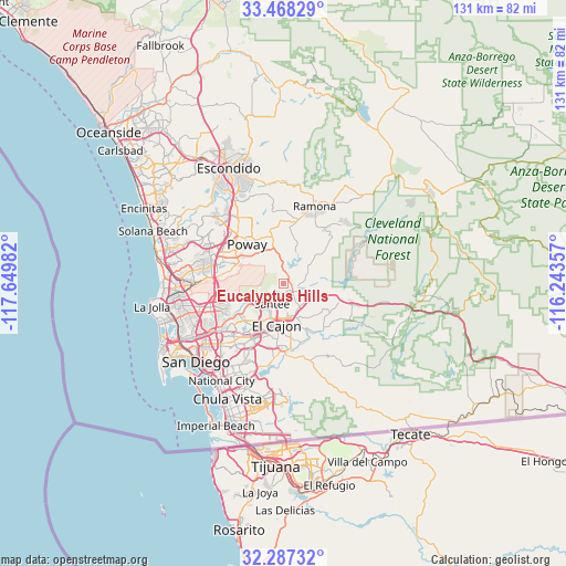
Eucalyptus Hills GPS coordinates[2]
32° 52' 47.172" North, 116° 56' 48.084" West
| Map corner | latitude | longitude |
|---|---|---|
| Upper-left | 33.46829°, | -117.64982° |
| Center: | 32.87977°, | -116.94669° |
| Lower-right: | 32.28732°, | -116.24357° |
| Map W x H: | 131.3×131.3 km | = 81.6×81.6mi |
| max Lat: | 71.29058° ⇑85.6% North |
| Eucalyptus Hills: | 32.87977° |
| min Lat: | ⇓14.4% South 19.06759° |
| min Long | Eucalyptus Hill | max Long |
| -171.73463° | -116.94669° | -66.98998° |
| W 10.3%⇐ | ⇒89.7% E |
Elevation
Elevation of Eucalyptus Hills is 201 m = 659 ft, and this is 93.8 m = 308 ft below average elevation for this country.
| Max E: |
3189 m = 10463 ft | 49.3% |
| Avg. | 294.8 m = 967 ft | |
| Eucalyptus Hills | 201 m = 659 ft | |
Min E: |
-60 m = -197 ft | 50.7% |
See also: United States elevation on elevation.city.
Geographical zone
Eucalyptus Hills is located in North temperate zone (between Tropic of Cancer and the Arctic Circle). Distance of this Northern Tropic circle is 1050 km =652.4 mi to South.| Distance of | km | miles | from Eucalyptus Hills |
|---|---|---|---|
| North Pole | 6351.2 | 3946.5 | to North |
| Arctic Circle | 3745.3 | 2327.2 | to North |
| Tropic Cancer | 1050 | 652.4 | to South |
| Equator | 3655.9 | 2271.7 | to South |


Nearby cities:
15 places around Eucalyptus Hills: (largest is in red/bold)
• Alpine
17.6 km =10.9 mi,  106°
106°
• Bostonia
8.1 km =5 mi,  173°
173°
• Casa de Oro-Mount Helix
13 km =8.1 mi,  189°
189°
• Crest
10.9 km =6.8 mi,  137°
137°
• El Cajon
9.6 km =6 mi, 188°
• Granite Hills
9.4 km =5.8 mi,  155°
155°
• Harbison Canyon
12.7 km =7.9 mi,  121°
121°
• La Mesa
14.3 km =8.9 mi,  209°
209°
• Lakeside
3.4 km =2.1 mi, 137°
• Lemon Grove
17.2 km =10.7 mi, 207°
• Poway
12.4 km =7.7 mi,  317°
317°
• Rancho San Diego
14.8 km =9.2 mi,  175°
175°
• Santee
5.3 km =3.3 mi, 208°
• Spring Valley
15.8 km =9.8 mi,  198°
198°
• Winter Gardens
5.5 km =3.4 mi, 167°
Sources, notices
• [Note1] Compared only with cities in United States existing in our database
• [Src1] Map data: © OpenStreetMap contributors (CC-BY-SA)
• [Src2] Other city data from geonames.org with taken over terms of usage.
• [Src3] Geographical zone / Annual Mean Temperature by Robert A. Rohde @ Wikipedia
