Florin geodata
Florin (California) is a populated place; located in United States in America/Los_Angeles (GMT-7) time zone. With population of 47,513 people, there are 1013 cities with bigger population in this country. Compared to other cities in United States, 58.8% of cities are located further ↑North; 94.2% of cities are located further →East and 93.9% of cities have higher elevation than Florin. Note1


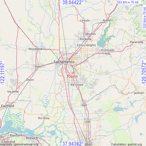
Florin GPS coordinates[2]
38° 29' 45.672" North, 121° 24' 31.824" West
| Map corner | latitude | longitude |
|---|---|---|
| Upper-left | 39.04422°, | -122.11197° |
| Center: | 38.49602°, | -121.40884° |
| Lower-right: | 37.94362°, | -120.70572° |
| Map W x H: | 122.4×122.4 km | = 76.1×76.1mi |
| max Lat: | 71.29058° ⇑58.8% North |
| Florin: | 38.49602° |
| min Lat: | ⇓41.2% South 19.06759° |
| min Long | Florin | max Long |
| -171.73463° | -121.40884° | -66.98998° |
| W 5.8%⇐ | ⇒94.2% E |
Elevation
Elevation of Florin is 10 m = 33 ft, and this is 284.8 m = 934 ft below average elevation for this country.
| Max E: |
3189 m = 10463 ft | 93.9% |
| Avg. | 294.8 m = 967 ft | |
| Florin | 10 m = 33 ft | |
Min E: |
-60 m = -197 ft | 6.1% |
See also: Florin elevation on elevation.city.
Geographical zone
Florin is located in North temperate zone (between Tropic of Cancer and the Arctic Circle). Distance of this Northern Tropic circle is 1674.4 km =1040.4 mi to South.| Distance of | km | miles | from Florin |
|---|---|---|---|
| North Pole | 5726.7 | 3558.4 | to North |
| Arctic Circle | 3120.8 | 1939.2 | to North |
| Tropic Cancer | 1674.4 | 1040.4 | to South |
| Equator | 4280.4 | 2659.7 | to South |


Nearby cities:
15 places around Florin: (largest is in red/bold)
• Arden-Arcade
12.1 km =7.5 mi,  12°
12°
• Carmichael
15.2 km =9.4 mi,  27°
27°
• Elk Grove
10.2 km =6.3 mi,  161°
161°
• Fruitridge Pocket
5.8 km =3.6 mi,  314°
314°
• Gold River
20.2 km =12.6 mi,  44°
44°
• La Riviera
9.1 km =5.7 mi, 29°
• Laguna
8.4 km =5.2 mi,  188°
188°
• McClellan Park
18.5 km =11.5 mi,  1°
1°
• Parkway
4.4 km =2.7 mi,  270°
270°
• Rancho Cordova
13.9 km =8.6 mi, 41°
• Rosemont
7.3 km =4.5 mi, 31°
• Sacramento
12.1 km =7.5 mi,  321°
321°
• Vineyard
6.4 km =4 mi,  123°
123°
• West Sacramento
14.1 km =8.8 mi, 311°
• Wilton
15.1 km =9.4 mi,  128°
128°
Sources, notices
• [Note1] Compared only with cities in United States existing in our database
• [Src1] Map data: © OpenStreetMap contributors (CC-BY-SA)
• [Src2] Other city data from geonames.org with taken over terms of usage.
• [Src3] Geographical zone / Annual Mean Temperature by Robert A. Rohde @ Wikipedia
