Laguna geodata
Laguna (California) is a section of populated place; located in United States in America/Los_Angeles (GMT-7) time zone. With population of 46,621 people, there are 1032 cities with bigger population in this country. Compared to other cities in United States, 59.2% of cities are located further ↑North; 94.3% of cities are located further →East and 94.8% of cities have higher elevation than Laguna. Note1


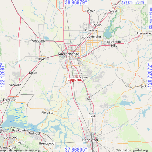
Laguna GPS coordinates[2]
38° 25' 15.672" North, 121° 25' 25.824" West
| Map corner | latitude | longitude |
|---|---|---|
| Upper-left | 38.96979°, | -122.12697° |
| Center: | 38.42102°, | -121.42384° |
| Lower-right: | 37.86805°, | -120.72072° |
| Map W x H: | 122.5×122.5 km | = 76.1×76.1mi |
| max Lat: | 71.29058° ⇑59.2% North |
| Laguna: | 38.42102° |
| min Lat: | ⇓40.8% South 19.06759° |
| min Long | Laguna | max Long |
| -171.73463° | -121.42384° | -66.98998° |
| W 5.7%⇐ | ⇒94.3% E |
Elevation
Elevation of Laguna is 9 m = 30 ft, and this is 285.8 m = 938 ft below average elevation for this country.
| Max E: |
3189 m = 10463 ft | 94.8% |
| Avg. | 294.8 m = 967 ft | |
| Laguna | 9 m = 30 ft | |
Min E: |
-60 m = -197 ft | 5.2% |
See also: Laguna elevation on elevation.city.
Geographical zone
Laguna is located in North temperate zone (between Tropic of Cancer and the Arctic Circle). Distance of this Northern Tropic circle is 1666.1 km =1035.3 mi to South.| Distance of | km | miles | from Laguna |
|---|---|---|---|
| North Pole | 5735 | 3563.6 | to North |
| Arctic Circle | 3129.2 | 1944.4 | to North |
| Tropic Cancer | 1666.1 | 1035.3 | to South |
| Equator | 4272 | 2654.5 | to South |


Nearby cities:
15 places around Laguna: (largest is in red/bold)
• Arden-Arcade
20.6 km =12.8 mi,  11°
11°
• Elk Grove
4.7 km =2.9 mi,  106°
106°
• Florin
8.4 km =5.2 mi, 8°
• Fruitridge Pocket
12.7 km =7.9 mi,  347°
347°
• Galt
21.4 km =13.3 mi,  149°
149°
• Herald
20.9 km =13 mi,  131°
131°
• La Riviera
17.2 km =10.7 mi,  19°
19°
• Parkway
8.9 km =5.5 mi,  339°
339°
• Rancho Cordova
21.5 km =13.4 mi,  29°
29°
• Rosemont
15.4 km =9.6 mi, 19°
• Sacramento
18.9 km =11.7 mi, 341°
• Vineyard
8.3 km =5.2 mi,  54°
54°
• Walnut Grove
21.3 km =13.2 mi,  201°
201°
• West Sacramento
20 km =12.4 mi,  332°
332°
• Wilton
13.3 km =8.3 mi,  94°
94°
Sources, notices
• [Note1] Compared only with cities in United States existing in our database
• [Src1] Map data: © OpenStreetMap contributors (CC-BY-SA)
• [Src2] Other city data from geonames.org with taken over terms of usage.
• [Src3] Geographical zone / Annual Mean Temperature by Robert A. Rohde @ Wikipedia
