Sacramento geodata
Sacramento (California) is a seat of a first-order administrative division; located in United States in America/Los_Angeles (GMT-7) time zone. With population of 490,712 people, there are 39 cities with bigger population in this country. Compared to other cities in United States, 58.2% of cities are located further ↑North; 94.3% of cities are located further →East and 91% of cities have higher elevation than Sacramento. Note1


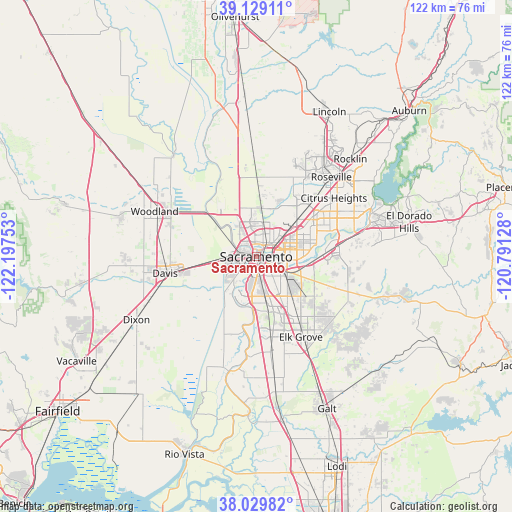
Sacramento GPS coordinates[2]
38° 34' 53.652" North, 121° 29' 39.84" West
| Map corner | latitude | longitude |
|---|---|---|
| Upper-left | 39.12911°, | -122.19753° |
| Center: | 38.58157°, | -121.4944° |
| Lower-right: | 38.02982°, | -120.79128° |
| Map W x H: | 122.2×122.2 km | = 75.9×75.9mi |
| max Lat: | 71.29058° ⇑58.2% North |
| Sacramento: | 38.58157° |
| min Lat: | ⇓41.8% South 19.06759° |
| min Long | Sacramento | max Long |
| -171.73463° | -121.4944° | -66.98998° |
| W 5.7%⇐ | ⇒94.3% E |
Elevation
Elevation of Sacramento is 14 m = 46 ft, and this is 280.8 m = 921 ft below average elevation for this country.
| Max E: |
3189 m = 10463 ft | 91% |
| Avg. | 294.8 m = 967 ft | |
| Sacramento | 14 m = 46 ft | |
Min E: |
-60 m = -197 ft | 9% |
See also: Sacramento elevation on elevation.city.
Geographical zone
Sacramento is located in North temperate zone (between Tropic of Cancer and the Arctic Circle). Distance of this Northern Tropic circle is 1683.9 km =1046.3 mi to South.| Distance of | km | miles | from Sacramento |
|---|---|---|---|
| North Pole | 5717.2 | 3552.5 | to North |
| Arctic Circle | 3111.3 | 1933.3 | to North |
| Tropic Cancer | 1683.9 | 1046.3 | to South |
| Equator | 4289.9 | 2665.6 | to South |


Nearby cities:
15 places around Sacramento: (largest is in red/bold)
• Arden-Arcade
10.3 km =6.4 mi,  76°
76°
• Carmichael
15 km =9.3 mi,  74°
74°
• Elverta
15 km =9.3 mi,  10°
10°
• Florin
12.1 km =7.5 mi,  141°
141°
• Foothill Farms
16.5 km =10.3 mi,  49°
49°
• Fruitridge Pocket
6.4 km =4 mi,  148°
148°
• La Riviera
12.1 km =7.5 mi,  97°
97°
• McClellan Park
12.1 km =7.5 mi,  41°
41°
• North Highlands
15.7 km =9.8 mi, 42°
• Parkway
10 km =6.2 mi,  161°
161°
• Rancho Cordova
16.7 km =10.4 mi,  87°
87°
• Rio Linda
12.8 km =8 mi,  18°
18°
• Rosemont
11.8 km =7.3 mi,  106°
106°
• Vineyard
18.3 km =11.4 mi, 135°
• West Sacramento
3.1 km =1.9 mi,  267°
267°
Sources, notices
• [Note1] Compared only with cities in United States existing in our database
• [Src1] Map data: © OpenStreetMap contributors (CC-BY-SA)
• [Src2] Other city data from geonames.org with taken over terms of usage.
• [Src3] Geographical zone / Annual Mean Temperature by Robert A. Rohde @ Wikipedia
