Hillsborough geodata
Hillsborough (California) is a populated place; located in United States in America/Los_Angeles (GMT-7) time zone. With population of 11,451 people, there are 4038 cities with bigger population in this country. Compared to other cities in United States, 63.8% of cities are located further ↑North; 96.3% of cities are located further →East and 71.3% of cities have higher elevation than Hillsborough. Note1


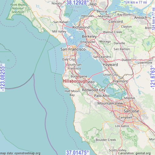
Hillsborough GPS coordinates[2]
37° 34' 26.76" North, 122° 22' 45.912" West
| Map corner | latitude | longitude |
|---|---|---|
| Upper-left | 38.12928°, | -123.08255° |
| Center: | 37.5741°, | -122.37942° |
| Lower-right: | 37.01475°, | -121.6763° |
| Map W x H: | 123.9×123.9 km | = 77×77mi |
| max Lat: | 71.29058° ⇑63.8% North |
| Hillsborough: | 37.5741° |
| min Lat: | ⇓36.2% South 19.06759° |
| min Long | Hillsborough | max Long |
| -171.73463° | -122.37942° | -66.98998° |
| W 3.7%⇐ | ⇒96.3% E |
Elevation
Elevation of Hillsborough is 93 m = 305 ft, and this is 201.8 m = 662 ft below average elevation for this country.
| Max E: |
3189 m = 10463 ft | 71.3% |
| Avg. | 294.8 m = 967 ft | |
| Hillsborough | 93 m = 305 ft | |
Min E: |
-60 m = -197 ft | 28.7% |
See also: United States elevation on elevation.city.
Geographical zone
Hillsborough is located in North temperate zone (between Tropic of Cancer and the Arctic Circle). Distance of this Northern Tropic circle is 1571.9 km =976.7 mi to South.| Distance of | km | miles | from Hillsborough |
|---|---|---|---|
| North Pole | 5829.2 | 3622.1 | to North |
| Arctic Circle | 3223.3 | 2002.9 | to North |
| Tropic Cancer | 1571.9 | 976.7 | to South |
| Equator | 4177.8 | 2596 | to South |


Nearby cities:
15 places around Hillsborough: (largest is in red/bold)
• Belmont
10.9 km =6.8 mi,  123°
123°
• Brisbane
12 km =7.5 mi,  351°
351°
• Burlingame
1.6 km =1 mi,  46°
46°
• El Granada
11.2 km =7 mi,  224°
224°
• Foster City
9.7 km =6 mi,  100°
100°
• Highlands-Baywood Park
6.5 km =4 mi,  152°
152°
• Millbrae
2.8 km =1.7 mi, 345°
• Montara
12.6 km =7.8 mi,  253°
253°
• Moss Beach
12.9 km =8 mi, 246°
• Pacifica
10.5 km =6.5 mi,  295°
295°
• Redwood Shores
12.5 km =7.8 mi,  112°
112°
• San Bruno
6.9 km =4.3 mi,  336°
336°
• San Carlos
12.9 km =8 mi,  125°
125°
• San Mateo
4.9 km =3 mi, 104°
• South San Francisco
9.3 km =5.8 mi, 344°
Sources, notices
• [Note1] Compared only with cities in United States existing in our database
• [Src1] Map data: © OpenStreetMap contributors (CC-BY-SA)
• [Src2] Other city data from geonames.org with taken over terms of usage.
• [Src3] Geographical zone / Annual Mean Temperature by Robert A. Rohde @ Wikipedia
