Montara geodata
Montara (California) is a populated place; located in United States in America/Los_Angeles (GMT-7) time zone. With population of 2,909 people, there are 9784 cities with bigger population in this country. Compared to other cities in United States, 63.9% of cities are located further ↑North; 96.6% of cities are located further →East and 83.8% of cities have higher elevation than Montara. Note1


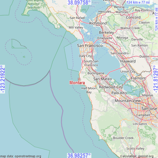
Montara GPS coordinates[2]
37° 32' 31.776" North, 122° 30' 57.924" West
| Map corner | latitude | longitude |
|---|---|---|
| Upper-left | 38.09758°, | -123.21922° |
| Center: | 37.54216°, | -122.51609° |
| Lower-right: | 36.98257°, | -121.81297° |
| Map W x H: | 124×124 km | = 77.1×77.1mi |
| max Lat: | 71.29058° ⇑63.9% North |
| Montara: | 37.54216° |
| min Lat: | ⇓36.1% South 19.06759° |
| min Long | Montara | max Long |
| -171.73463° | -122.51609° | -66.98998° |
| W 3.4%⇐ | ⇒96.6% E |
Elevation
Elevation of Montara is 32 m = 105 ft, and this is 262.8 m = 862 ft below average elevation for this country.
| Max E: |
3189 m = 10463 ft | 83.8% |
| Avg. | 294.8 m = 967 ft | |
| Montara | 32 m = 105 ft | |
Min E: |
-60 m = -197 ft | 16.2% |
See also: United States elevation on elevation.city.
Geographical zone
Montara is located in North temperate zone (between Tropic of Cancer and the Arctic Circle). Distance of this Northern Tropic circle is 1568.4 km =974.6 mi to South.| Distance of | km | miles | from Montara |
|---|---|---|---|
| North Pole | 5832.8 | 3624.3 | to North |
| Arctic Circle | 3226.9 | 2005.1 | to North |
| Tropic Cancer | 1568.4 | 974.6 | to South |
| Equator | 4174.3 | 2593.8 | to South |


Nearby cities:
15 places around Montara: (largest is in red/bold)
• Brisbane
18.5 km =11.5 mi,  33°
33°
• Broadmoor
16.3 km =10.1 mi,  10°
10°
• Burlingame
14 km =8.7 mi,  70°
70°
• Colma
15.8 km =9.8 mi,  18°
18°
• Daly City
18.8 km =11.7 mi, 14°
• El Granada
6 km =3.7 mi,  136°
136°
• Half Moon Bay
11.7 km =7.3 mi, 138°
• Highlands-Baywood Park
15.2 km =9.4 mi,  98°
98°
• Hillsborough
12.6 km =7.8 mi, 73°
• Millbrae
13 km =8.1 mi,  61°
61°
• Moss Beach
1.7 km =1.1 mi,  171°
171°
• Pacifica
8.4 km =5.2 mi, 17°
• San Bruno
13.5 km =8.4 mi,  43°
43°
• San Mateo
17 km =10.6 mi,  82°
82°
• South San Francisco
15.7 km =9.8 mi, 37°
Sources, notices
• [Note1] Compared only with cities in United States existing in our database
• [Src1] Map data: © OpenStreetMap contributors (CC-BY-SA)
• [Src2] Other city data from geonames.org with taken over terms of usage.
• [Src3] Geographical zone / Annual Mean Temperature by Robert A. Rohde @ Wikipedia
