Imperial Beach geodata
Imperial Beach (California) is a populated place; located in United States in America/Los_Angeles (GMT-7) time zone. With population of 27,408 people, there are 1828 cities with bigger population in this country. Compared to other cities in United States, 86.8% of cities are located further ↑North; 89.9% of cities are located further →East and 96.6% of cities have higher elevation than Imperial Beach. Note1


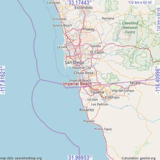
Imperial Beach GPS coordinates[2]
32° 35' 2.184" North, 117° 6' 47.088" West
| Map corner | latitude | longitude |
|---|---|---|
| Upper-left | 33.17443°, | -117.81621° |
| Center: | 32.58394°, | -117.11308° |
| Lower-right: | 31.98953°, | -116.40996° |
| Map W x H: | 131.7×131.7 km | = 81.8×81.8mi |
| max Lat: | 71.29058° ⇑86.8% North |
| Imperial Beach: | 32.58394° |
| min Lat: | ⇓13.2% South 19.06759° |
| min Long | Imperial Beach | max Long |
| -171.73463° | -117.11308° | -66.98998° |
| W 10.1%⇐ | ⇒89.9% E |
Elevation
Elevation of Imperial Beach is 7 m = 23 ft, and this is 287.8 m = 944 ft below average elevation for this country.
| Max E: |
3189 m = 10463 ft | 96.6% |
| Avg. | 294.8 m = 967 ft | |
| Imperial Beach | 7 m = 23 ft | |
Min E: |
-60 m = -197 ft | 3.4% |
See also: United States elevation on elevation.city.
Geographical zone
Imperial Beach is located in North temperate zone (between Tropic of Cancer and the Arctic Circle). Distance of this Northern Tropic circle is 1017.1 km =632 mi to South.| Distance of | km | miles | from Imperial Beach |
|---|---|---|---|
| North Pole | 6384.1 | 3966.9 | to North |
| Arctic Circle | 3778.2 | 2347.7 | to North |
| Tropic Cancer | 1017.1 | 632 | to South |
| Equator | 3623 | 2251.2 | to South |


Nearby cities:
15 places around Imperial Beach: (largest is in red/bold)
• Bonita
11.3 km =7 mi,  43°
43°
• Bostonia
29.9 km =18.6 mi,  33°
33°
• Casa de Oro-Mount Helix
24.1 km =15 mi, 34°
• Chula Vista
6.8 km =4.2 mi,  23°
23°
• Coronado
13.1 km =8.1 mi,  329°
329°
• El Cajon
27.3 km =17 mi, 31°
• Jamul
26.7 km =16.6 mi,  56°
56°
• La Mesa
22.1 km =13.7 mi, 22°
• La Presa
17.6 km =10.9 mi, 38°
• Lemon Grove
19.2 km =11.9 mi, 23°
• National City
10.6 km =6.6 mi,  7°
7°
• Rancho San Diego
24.6 km =15.3 mi, 42°
• San Diego
15.4 km =9.6 mi,  341°
341°
• Santee
31.1 km =19.3 mi, 24°
• Spring Valley
20.8 km =12.9 mi, 30°
Sources, notices
• [Note1] Compared only with cities in United States existing in our database
• [Src1] Map data: © OpenStreetMap contributors (CC-BY-SA)
• [Src2] Other city data from geonames.org with taken over terms of usage.
• [Src3] Geographical zone / Annual Mean Temperature by Robert A. Rohde @ Wikipedia
