Irvine geodata
Irvine (California) is a populated place; located in United States in America/Los_Angeles (GMT-7) time zone. With population of 256,927 people, there are 89 cities with bigger population in this country. Compared to other cities in United States, 82.2% of cities are located further ↑North; 90.6% of cities are located further →East and 87.4% of cities have higher elevation than Irvine. Note1


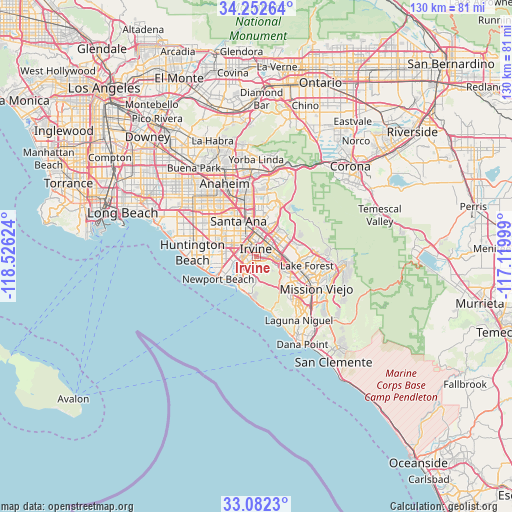
Irvine GPS coordinates[2]
33° 40' 10.056" North, 117° 49' 23.196" West
| Map corner | latitude | longitude |
|---|---|---|
| Upper-left | 34.25264°, | -118.52624° |
| Center: | 33.66946°, | -117.82311° |
| Lower-right: | 33.0823°, | -117.11999° |
| Map W x H: | 130.1×130.1 km | = 80.8×80.8mi |
| max Lat: | 71.29058° ⇑82.2% North |
| Irvine: | 33.66946° |
| min Lat: | ⇓17.8% South 19.06759° |
| min Long | Irvine | max Long |
| -171.73463° | -117.82311° | -66.98998° |
| W 9.4%⇐ | ⇒90.6% E |
Elevation
Elevation of Irvine is 22 m = 72 ft, and this is 272.8 m = 895 ft below average elevation for this country.
| Max E: |
3189 m = 10463 ft | 87.4% |
| Avg. | 294.8 m = 967 ft | |
| Irvine | 22 m = 72 ft | |
Min E: |
-60 m = -197 ft | 12.6% |
See also: Irvine elevation on elevation.city.
Geographical zone
Irvine is located in North temperate zone (between Tropic of Cancer and the Arctic Circle). Distance of this Northern Tropic circle is 1137.8 km =707 mi to South.| Distance of | km | miles | from Irvine |
|---|---|---|---|
| North Pole | 6263.4 | 3891.9 | to North |
| Arctic Circle | 3657.5 | 2272.7 | to North |
| Tropic Cancer | 1137.8 | 707 | to South |
| Equator | 3743.7 | 2326.2 | to South |


Nearby cities:
15 places around Irvine: (largest is in red/bold)
• Aliso Viejo
14.6 km =9.1 mi,  142°
142°
• Costa Mesa
9.4 km =5.8 mi,  250°
250°
• Foothill Ranch
15.1 km =9.4 mi,  82°
82°
• Fountain Valley
12.9 km =8 mi,  290°
290°
• Laguna Beach
14.6 km =9.1 mi,  165°
165°
• Laguna Hills
12 km =7.5 mi,  121°
121°
• Laguna Woods
11.2 km =7 mi,  126°
126°
• Lake Forest
12.6 km =7.8 mi,  101°
101°
• Mission Viejo
16 km =9.9 mi, 118°
• Newport Beach
11.3 km =7 mi,  240°
240°
• North Tustin
10.9 km =6.8 mi,  14°
14°
• Orange
13.4 km =8.3 mi,  348°
348°
• San Joaquin Hills
6.5 km =4 mi,  191°
191°
• Santa Ana
9.4 km =5.8 mi,  333°
333°
• Tustin
8.5 km =5.3 mi,  358°
358°
Sources, notices
• [Note1] Compared only with cities in United States existing in our database
• [Src1] Map data: © OpenStreetMap contributors (CC-BY-SA)
• [Src2] Other city data from geonames.org with taken over terms of usage.
• [Src3] Geographical zone / Annual Mean Temperature by Robert A. Rohde @ Wikipedia
