Orange geodata
Orange (California) is a seat of a second-order administrative division; located in United States in America/Los_Angeles (GMT-7) time zone. With population of 140,992 people, there are 211 cities with bigger population in this country. Compared to other cities in United States, 81.6% of cities are located further ↑North; 90.7% of cities are located further →East and 76.9% of cities have higher elevation than Orange. Note1


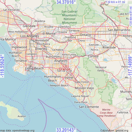
Orange GPS coordinates[2]
33° 47' 16.044" North, 117° 51' 11.196" West
| Map corner | latitude | longitude |
|---|---|---|
| Upper-left | 34.37016°, | -118.55624° |
| Center: | 33.78779°, | -117.85311° |
| Lower-right: | 33.20143°, | -117.14999° |
| Map W x H: | 130×130 km | = 80.8×80.8mi |
| max Lat: | 71.29058° ⇑81.6% North |
| Orange: | 33.78779° |
| min Lat: | ⇓18.4% South 19.06759° |
| min Long | Orange | max Long |
| -171.73463° | -117.85311° | -66.98998° |
| W 9.3%⇐ | ⇒90.7% E |
Elevation
Elevation of Orange is 61 m = 200 ft, and this is 233.8 m = 767 ft below average elevation for this country.
| Max E: |
3189 m = 10463 ft | 76.9% |
| Avg. | 294.8 m = 967 ft | |
| Orange | 61 m = 200 ft | |
Min E: |
-60 m = -197 ft | 23.1% |
See also: Orange elevation on elevation.city.
Geographical zone
Orange is located in North temperate zone (between Tropic of Cancer and the Arctic Circle). Distance of this Northern Tropic circle is 1150.9 km =715.1 mi to South.| Distance of | km | miles | from Orange |
|---|---|---|---|
| North Pole | 6250.2 | 3883.7 | to North |
| Arctic Circle | 3644.3 | 2264.5 | to North |
| Tropic Cancer | 1150.9 | 715.1 | to South |
| Equator | 3756.9 | 2334.4 | to South |


Nearby cities:
15 places around Orange: (largest is in red/bold)
• Anaheim
7.7 km =4.8 mi,  312°
312°
• Brea
15 km =9.3 mi,  343°
343°
• Fountain Valley
12.8 km =8 mi,  226°
226°
• Fullerton
11.3 km =7 mi,  323°
323°
• Garden Grove
8.3 km =5.2 mi,  259°
259°
• Irvine
13.4 km =8.3 mi,  168°
168°
• Midway City
13.5 km =8.4 mi,  249°
249°
• North Tustin
6.1 km =3.8 mi,  115°
115°
• Placentia
9.5 km =5.9 mi,  350°
350°
• Santa Ana
4.9 km =3 mi,  196°
196°
• Stanton
13 km =8.1 mi,  277°
277°
• Tustin
5.3 km =3.3 mi,  151°
151°
• Villa Park
4.7 km =2.9 mi,  51°
51°
• Westminster
14.6 km =9.1 mi, 257°
• Yorba Linda
11.8 km =7.3 mi,  18°
18°
Sources, notices
• [Note1] Compared only with cities in United States existing in our database
• [Src1] Map data: © OpenStreetMap contributors (CC-BY-SA)
• [Src2] Other city data from geonames.org with taken over terms of usage.
• [Src3] Geographical zone / Annual Mean Temperature by Robert A. Rohde @ Wikipedia
