Tustin geodata
Tustin (California) is a populated place; located in United States in America/Los_Angeles (GMT-7) time zone. With population of 80,583 people, there are 489 cities with bigger population in this country. Compared to other cities in United States, 81.8% of cities are located further ↑North; 90.6% of cities are located further →East and 80.1% of cities have higher elevation than Tustin. Note1


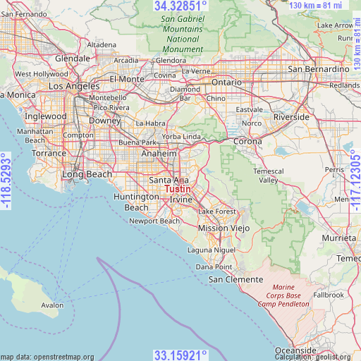
Tustin GPS coordinates[2]
33° 44' 45.06" North, 117° 49' 34.212" West
| Map corner | latitude | longitude |
|---|---|---|
| Upper-left | 34.32851°, | -118.5293° |
| Center: | 33.74585°, | -117.82617° |
| Lower-right: | 33.15921°, | -117.12305° |
| Map W x H: | 130×130 km | = 80.8×80.8mi |
| max Lat: | 71.29058° ⇑81.8% North |
| Tustin: | 33.74585° |
| min Lat: | ⇓18.2% South 19.06759° |
| min Long | Tustin | max Long |
| -171.73463° | -117.82617° | -66.98998° |
| W 9.4%⇐ | ⇒90.6% E |
Elevation
Elevation of Tustin is 46 m = 151 ft, and this is 248.8 m = 816 ft below average elevation for this country.
| Max E: |
3189 m = 10463 ft | 80.1% |
| Avg. | 294.8 m = 967 ft | |
| Tustin | 46 m = 151 ft | |
Min E: |
-60 m = -197 ft | 19.9% |
See also: Tustin elevation on elevation.city.
Geographical zone
Tustin is located in North temperate zone (between Tropic of Cancer and the Arctic Circle). Distance of this Northern Tropic circle is 1146.3 km =712.3 mi to South.| Distance of | km | miles | from Tustin |
|---|---|---|---|
| North Pole | 6254.9 | 3886.6 | to North |
| Arctic Circle | 3649 | 2267.4 | to North |
| Tropic Cancer | 1146.3 | 712.3 | to South |
| Equator | 3752.2 | 2331.5 | to South |


Nearby cities:
15 places around Tustin: (largest is in red/bold)
• Anaheim
12.9 km =8 mi,  320°
320°
• Costa Mesa
14.5 km =9 mi,  216°
216°
• Foothill Ranch
16.7 km =10.4 mi,  113°
113°
• Fountain Valley
12.5 km =7.8 mi,  250°
250°
• Fullerton
16.6 km =10.3 mi,  326°
326°
• Garden Grove
11.1 km =6.9 mi,  286°
286°
• Irvine
8.5 km =5.3 mi,  178°
178°
• Midway City
15.1 km =9.4 mi,  269°
269°
• North Tustin
3.6 km =2.2 mi,  55°
55°
• Orange
5.3 km =3.3 mi, 331°
• Placentia
14.6 km =9.1 mi,  343°
343°
• San Joaquin Hills
14.9 km =9.3 mi, 183°
• Santa Ana
3.9 km =2.4 mi, 269°
• Villa Park
7.7 km =4.8 mi,  8°
8°
• Yorba Linda
15.9 km =9.9 mi,  4°
4°
Sources, notices
• [Note1] Compared only with cities in United States existing in our database
• [Src1] Map data: © OpenStreetMap contributors (CC-BY-SA)
• [Src2] Other city data from geonames.org with taken over terms of usage.
• [Src3] Geographical zone / Annual Mean Temperature by Robert A. Rohde @ Wikipedia
