Mission Canyon geodata
Mission Canyon (California) is a populated place; located in United States in America/Los_Angeles (GMT-7) time zone. With population of 2,381 people, there are 10901 cities with bigger population in this country. Compared to other cities in United States, 77.8% of cities are located further ↑North; 92.6% of cities are located further →East and 51.9% of cities have higher elevation than Mission Canyon. Note1


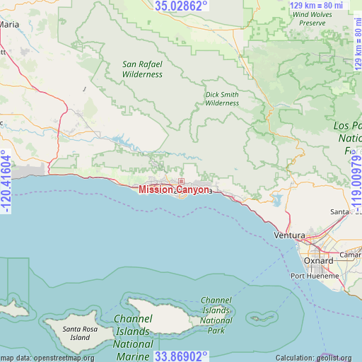
Mission Canyon GPS coordinates[2]
34° 27' 2.988" North, 119° 42' 46.476" West
| Map corner | latitude | longitude |
|---|---|---|
| Upper-left | 35.02862°, | -120.41604° |
| Center: | 34.45083°, | -119.71291° |
| Lower-right: | 33.86902°, | -119.00979° |
| Map W x H: | 128.9×128.9 km | = 80.1×80.1mi |
| max Lat: | 71.29058° ⇑77.8% North |
| Mission Canyon: | 34.45083° |
| min Lat: | ⇓22.2% South 19.06759° |
| min Long | Mission Canyon | max Long |
| -171.73463° | -119.71291° | -66.98998° |
| W 7.4%⇐ | ⇒92.6% E |
Elevation
Elevation of Mission Canyon is 191 m = 627 ft, and this is 103.8 m = 341 ft below average elevation for this country.
| Max E: |
3189 m = 10463 ft | 51.9% |
| Avg. | 294.8 m = 967 ft | |
| Mission Canyon | 191 m = 627 ft | |
Min E: |
-60 m = -197 ft | 48.1% |
See also: United States elevation on elevation.city.
Geographical zone
Mission Canyon is located in North temperate zone (between Tropic of Cancer and the Arctic Circle). Distance of this Northern Tropic circle is 1224.7 km =761 mi to South.| Distance of | km | miles | from Mission Canyon |
|---|---|---|---|
| North Pole | 6176.5 | 3837.9 | to North |
| Arctic Circle | 3570.6 | 2218.7 | to North |
| Tropic Cancer | 1224.7 | 761 | to South |
| Equator | 3830.6 | 2380.2 | to South |


Nearby cities:
15 places around Mission Canyon: (largest is in red/bold)
• Carpinteria
18.7 km =11.6 mi,  107°
107°
• Goleta
10.7 km =6.6 mi,  260°
260°
• Isla Vista
14.2 km =8.8 mi,  252°
252°
• Los Olivos
44 km =27.3 mi,  303°
303°
• Meiners Oaks
39.8 km =24.7 mi,  90°
90°
• Mira Monte
39.3 km =24.4 mi, 92°
• Montecito
7.6 km =4.7 mi,  102°
102°
• Oak View
38.3 km =23.8 mi, 98°
• Ojai
43.1 km =26.8 mi, 90°
• Santa Barbara
3.6 km =2.2 mi,  157°
157°
• Santa Ynez
38.2 km =23.7 mi, 298°
• Solvang
42.1 km =26.2 mi,  292°
292°
• Summerland
11.2 km =7 mi, 107°
• Toro Canyon
13.8 km =8.6 mi, 104°
• Ventura
43 km =26.7 mi,  116°
116°
Sources, notices
• [Note1] Compared only with cities in United States existing in our database
• [Src1] Map data: © OpenStreetMap contributors (CC-BY-SA)
• [Src2] Other city data from geonames.org with taken over terms of usage.
• [Src3] Geographical zone / Annual Mean Temperature by Robert A. Rohde @ Wikipedia
