Solvang geodata
Solvang (California) is a populated place; located in United States in America/Los_Angeles (GMT-7) time zone. With population of 5,741 people, there are 6581 cities with bigger population in this country. Compared to other cities in United States, 77.3% of cities are located further ↑North; 92.9% of cities are located further →East and 60.5% of cities have higher elevation than Solvang. Note1


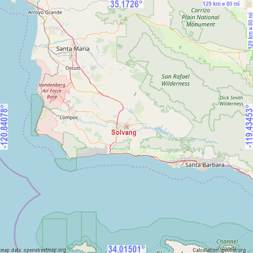
Solvang GPS coordinates[2]
34° 35' 44.952" North, 120° 8' 15.54" West
| Map corner | latitude | longitude |
|---|---|---|
| Upper-left | 35.1726°, | -120.84078° |
| Center: | 34.59582°, | -120.13765° |
| Lower-right: | 34.01501°, | -119.43453° |
| Map W x H: | 128.7×128.7 km | = 80×80mi |
| max Lat: | 71.29058° ⇑77.3% North |
| Solvang: | 34.59582° |
| min Lat: | ⇓22.7% South 19.06759° |
| min Long | Solvang | max Long |
| -171.73463° | -120.13765° | -66.98998° |
| W 7.1%⇐ | ⇒92.9% E |
Elevation
Elevation of Solvang is 152 m = 499 ft, and this is 142.8 m = 469 ft below average elevation for this country.
| Max E: |
3189 m = 10463 ft | 60.5% |
| Avg. | 294.8 m = 967 ft | |
| Solvang | 152 m = 499 ft | |
Min E: |
-60 m = -197 ft | 39.5% |
See also: United States elevation on elevation.city.
Geographical zone
Solvang is located in North temperate zone (between Tropic of Cancer and the Arctic Circle). Distance of this Northern Tropic circle is 1240.8 km =771 mi to South.| Distance of | km | miles | from Solvang |
|---|---|---|---|
| North Pole | 6160.4 | 3827.9 | to North |
| Arctic Circle | 3554.5 | 2208.7 | to North |
| Tropic Cancer | 1240.8 | 771 | to South |
| Equator | 3846.7 | 2390.2 | to South |


Nearby cities:
15 places around Solvang: (largest is in red/bold)
• Buellton
5.4 km =3.4 mi,  291°
291°
• Goleta
33.5 km =20.8 mi,  122°
122°
• Isla Vista
32.5 km =20.2 mi,  128°
128°
• Lompoc
29.7 km =18.5 mi,  279°
279°
• Los Alamos
20.9 km =13 mi,  322°
322°
• Los Olivos
8.3 km =5.2 mi,  14°
14°
• Mission Canyon
42.1 km =26.2 mi,  112°
112°
• Mission Hills
29.2 km =18.1 mi, 290°
• Montecito
49.6 km =30.8 mi, 110°
• Orcutt
40.5 km =25.2 mi, 317°
• Santa Barbara
44.7 km =27.8 mi, 115°
• Santa Maria
48.2 km =30 mi,  325°
325°
• Santa Ynez
5.7 km =3.5 mi,  68°
68°
• Vandenberg Air Force Base
38.7 km =24 mi,  295°
295°
• Vandenberg Village
32.7 km =20.3 mi, 292°
Sources, notices
• [Note1] Compared only with cities in United States existing in our database
• [Src1] Map data: © OpenStreetMap contributors (CC-BY-SA)
• [Src2] Other city data from geonames.org with taken over terms of usage.
• [Src3] Geographical zone / Annual Mean Temperature by Robert A. Rohde @ Wikipedia
