Ventura geodata
Ventura (California) is a seat of a second-order administrative division; located in United States in America/Los_Angeles (GMT-7) time zone. With population of 96,769 people, there are 366 cities with bigger population in this country. Compared to other cities in United States, 78.5% of cities are located further ↑North; 92.2% of cities are located further →East and 92.1% of cities have higher elevation than Ventura. Note1


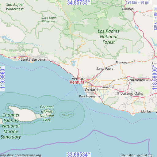
Ventura GPS coordinates[2]
34° 16' 42.024" North, 119° 17' 35.412" West
| Map corner | latitude | longitude |
|---|---|---|
| Upper-left | 34.85733°, | -119.9963° |
| Center: | 34.27834°, | -119.29317° |
| Lower-right: | 33.69534°, | -118.59005° |
| Map W x H: | 129.2×129.2 km | = 80.3×80.3mi |
| max Lat: | 71.29058° ⇑78.5% North |
| Ventura: | 34.27834° |
| min Lat: | ⇓21.5% South 19.06759° |
| min Long | Ventura | max Long |
| -171.73463° | -119.29317° | -66.98998° |
| W 7.8%⇐ | ⇒92.2% E |
Elevation
Elevation of Ventura is 12 m = 39 ft, and this is 282.8 m = 928 ft below average elevation for this country.
| Max E: |
3189 m = 10463 ft | 92.1% |
| Avg. | 294.8 m = 967 ft | |
| Ventura | 12 m = 39 ft | |
Min E: |
-60 m = -197 ft | 7.9% |
See also: Ventura elevation on elevation.city.
Geographical zone
Ventura is located in North temperate zone (between Tropic of Cancer and the Arctic Circle). Distance of this Northern Tropic circle is 1205.5 km =749.1 mi to South.| Distance of | km | miles | from Ventura |
|---|---|---|---|
| North Pole | 6195.7 | 3849.8 | to North |
| Arctic Circle | 3589.8 | 2230.6 | to North |
| Tropic Cancer | 1205.5 | 749.1 | to South |
| Equator | 3811.4 | 2368.3 | to South |


Nearby cities:
15 places around Ventura: (largest is in red/bold)
• Camarillo
24.5 km =15.2 mi,  106°
106°
• Carpinteria
24.6 km =15.3 mi,  302°
302°
• Casa Conejo
33.8 km =21 mi, 108°
• Channel Islands Beach
14.8 km =9.2 mi,  154°
154°
• El Rio
12.8 km =8 mi, 111°
• Meiners Oaks
18.8 km =11.7 mi,  3°
3°
• Mira Monte
17.3 km =10.7 mi, 2°
• Oak View
13.5 km =8.4 mi,  357°
357°
• Ojai
19.4 km =12.1 mi,  13°
13°
• Oxnard
14 km =8.7 mi,  130°
130°
• Port Hueneme
17.1 km =10.6 mi, 148°
• Santa Paula
23.1 km =14.4 mi,  68°
68°
• Saticoy
13.2 km =8.2 mi,  87°
87°
• Summerland
32.1 km =19.9 mi, 299°
• Toro Canyon
29.7 km =18.5 mi, 302°
Sources, notices
• [Note1] Compared only with cities in United States existing in our database
• [Src1] Map data: © OpenStreetMap contributors (CC-BY-SA)
• [Src2] Other city data from geonames.org with taken over terms of usage.
• [Src3] Geographical zone / Annual Mean Temperature by Robert A. Rohde @ Wikipedia
