Novato geodata
Novato (California) is a populated place; located in United States in America/Los_Angeles (GMT-7) time zone. With population of 55,530 people, there are 827 cities with bigger population in this country. Compared to other cities in United States, 61.1% of cities are located further ↑North; 96.8% of cities are located further →East and 97.4% of cities have higher elevation than Novato. Note1


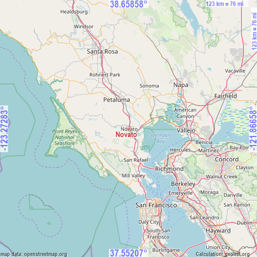
Novato GPS coordinates[2]
38° 6' 26.712" North, 122° 34' 10.92" West
| Map corner | latitude | longitude |
|---|---|---|
| Upper-left | 38.65858°, | -123.27283° |
| Center: | 38.10742°, | -122.5697° |
| Lower-right: | 37.55207°, | -121.86658° |
| Map W x H: | 123×123 km | = 76.4×76.4mi |
| max Lat: | 71.29058° ⇑61.1% North |
| Novato: | 38.10742° |
| min Lat: | ⇓38.9% South 19.06759° |
| min Long | Novato | max Long |
| -171.73463° | -122.5697° | -66.98998° |
| W 3.2%⇐ | ⇒96.8% E |
Elevation
Elevation of Novato is 6 m = 20 ft, and this is 288.8 m = 948 ft below average elevation for this country.
| Max E: |
3189 m = 10463 ft | 97.4% |
| Avg. | 294.8 m = 967 ft | |
| Novato | 6 m = 20 ft | |
Min E: |
-60 m = -197 ft | 2.6% |
See also: Novato elevation on elevation.city.
Geographical zone
Novato is located in North temperate zone (between Tropic of Cancer and the Arctic Circle). Distance of this Northern Tropic circle is 1631.2 km =1013.6 mi to South.| Distance of | km | miles | from Novato |
|---|---|---|---|
| North Pole | 5769.9 | 3585.2 | to North |
| Arctic Circle | 3164 | 1966 | to North |
| Tropic Cancer | 1631.2 | 1013.6 | to South |
| Equator | 4237.1 | 2632.8 | to South |


Nearby cities:
15 places around Novato: (largest is in red/bold)
• Black Point-Green Point
5 km =3.1 mi,  79°
79°
• Corte Madera
20.6 km =12.8 mi,  169°
169°
• Fairfax
13.5 km =8.4 mi,  187°
187°
• Kentfield
17.3 km =10.7 mi,  176°
176°
• Lagunitas-Forest Knolls
14.6 km =9.1 mi,  226°
226°
• Larkspur
19.5 km =12.1 mi, 171°
• Lucas Valley-Marinwood
7.5 km =4.7 mi, 183°
• Petaluma
15.1 km =9.4 mi,  337°
337°
• Ross
16.2 km =10.1 mi, 175°
• San Anselmo
14.8 km =9.2 mi, 177°
• San Rafael
15.3 km =9.5 mi, 167°
• Santa Venetia
12.7 km =7.9 mi,  162°
162°
• Sleepy Hollow
10.9 km =6.8 mi, 186°
• Temelec
18.9 km =11.7 mi,  20°
20°
• Woodacre
12.4 km =7.7 mi,  212°
212°
Sources, notices
• [Note1] Compared only with cities in United States existing in our database
• [Src1] Map data: © OpenStreetMap contributors (CC-BY-SA)
• [Src2] Other city data from geonames.org with taken over terms of usage.
• [Src3] Geographical zone / Annual Mean Temperature by Robert A. Rohde @ Wikipedia
