Petaluma geodata
Petaluma (California) is a populated place; located in United States in America/Los_Angeles (GMT-7) time zone. With population of 60,438 people, there are 738 cities with bigger population in this country. Compared to other cities in United States, 60.4% of cities are located further ↑North; 97% of cities are located further →East and 98.8% of cities have higher elevation than Petaluma. Note1


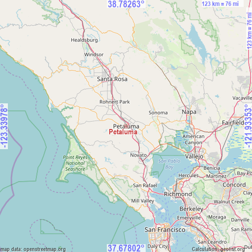
Petaluma GPS coordinates[2]
38° 13' 56.712" North, 122° 38' 11.94" West
| Map corner | latitude | longitude |
|---|---|---|
| Upper-left | 38.78263°, | -123.33978° |
| Center: | 38.23242°, | -122.63665° |
| Lower-right: | 37.67802°, | -121.93353° |
| Map W x H: | 122.8×122.8 km | = 76.3×76.3mi |
| max Lat: | 71.29058° ⇑60.4% North |
| Petaluma: | 38.23242° |
| min Lat: | ⇓39.6% South 19.06759° |
| min Long | Petaluma | max Long |
| -171.73463° | -122.63665° | -66.98998° |
| W 3%⇐ | ⇒97% E |
Elevation
Elevation of Petaluma is 4 m = 13 ft, and this is 290.8 m = 954 ft below average elevation for this country.
| Max E: |
3189 m = 10463 ft | 98.8% |
| Avg. | 294.8 m = 967 ft | |
| Petaluma | 4 m = 13 ft | |
Min E: |
-60 m = -197 ft | 1.2% |
See also: Petaluma elevation on elevation.city.
Geographical zone
Petaluma is located in North temperate zone (between Tropic of Cancer and the Arctic Circle). Distance of this Northern Tropic circle is 1645.1 km =1022.2 mi to South.| Distance of | km | miles | from Petaluma |
|---|---|---|---|
| North Pole | 5756 | 3576.6 | to North |
| Arctic Circle | 3150.1 | 1957.4 | to North |
| Tropic Cancer | 1645.1 | 1022.2 | to South |
| Equator | 4251 | 2641.4 | to South |


Nearby cities:
15 places around Petaluma: (largest is in red/bold)
• Black Point-Green Point
16.9 km =10.5 mi,  140°
140°
• Boyes Hot Springs
16.3 km =10.1 mi,  56°
56°
• Cotati
12.2 km =7.6 mi,  329°
329°
• El Verano
14.6 km =9.1 mi, 60°
• Eldridge
17 km =10.6 mi,  40°
40°
• Fetters Hot Springs-Agua Caliente
16.4 km =10.2 mi,  52°
52°
• Glen Ellen
17.6 km =10.9 mi,  33°
33°
• Kenwood
21.7 km =13.5 mi,  21°
21°
• Lucas Valley-Marinwood
22 km =13.7 mi,  165°
165°
• Novato
15.1 km =9.4 mi,  157°
157°
• Penngrove
7.9 km =4.9 mi,  340°
340°
• Rohnert Park
13.2 km =8.2 mi, 334°
• Roseland
22.5 km =14 mi, 339°
• Sonoma
16.9 km =10.5 mi,  67°
67°
• Temelec
13.1 km =8.1 mi, 73°
Sources, notices
• [Note1] Compared only with cities in United States existing in our database
• [Src1] Map data: © OpenStreetMap contributors (CC-BY-SA)
• [Src2] Other city data from geonames.org with taken over terms of usage.
• [Src3] Geographical zone / Annual Mean Temperature by Robert A. Rohde @ Wikipedia
