Rancho Murieta geodata
Rancho Murieta (California) is a populated place; located in United States in America/Los_Angeles (GMT-7) time zone. With population of 5,488 people, there are 6772 cities with bigger population in this country. Compared to other cities in United States, 58.8% of cities are located further ↑North; 93.9% of cities are located further →East and 78.8% of cities have higher elevation than Rancho Murieta. Note1


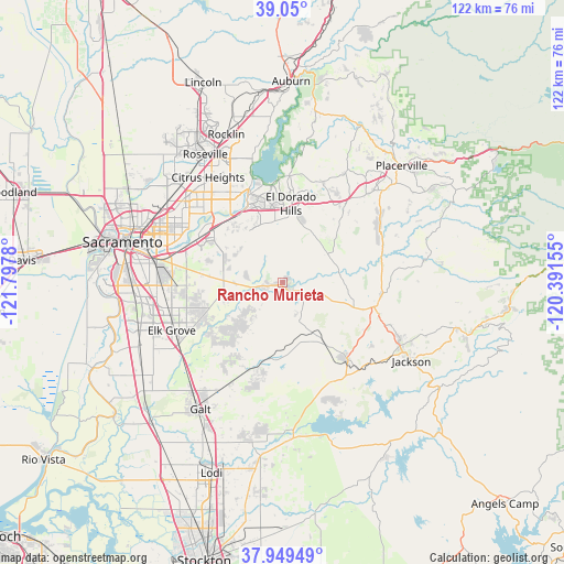
Rancho Murieta GPS coordinates[2]
38° 30' 6.66" North, 121° 5' 40.812" West
| Map corner | latitude | longitude |
|---|---|---|
| Upper-left | 39.05°, | -121.7978° |
| Center: | 38.50185°, | -121.09467° |
| Lower-right: | 37.94949°, | -120.39155° |
| Map W x H: | 122.4×122.4 km | = 76.1×76.1mi |
| max Lat: | 71.29058° ⇑58.8% North |
| Rancho Murieta: | 38.50185° |
| min Lat: | ⇓41.2% South 19.06759° |
| min Long | Rancho Murieta | max Long |
| -171.73463° | -121.09467° | -66.98998° |
| W 6.1%⇐ | ⇒93.9% E |
Elevation
Elevation of Rancho Murieta is 52 m = 171 ft, and this is 242.8 m = 797 ft below average elevation for this country.
| Max E: |
3189 m = 10463 ft | 78.8% |
| Avg. | 294.8 m = 967 ft | |
| Rancho Murieta | 52 m = 171 ft | |
Min E: |
-60 m = -197 ft | 21.2% |
See also: United States elevation on elevation.city.
Geographical zone
Rancho Murieta is located in North temperate zone (between Tropic of Cancer and the Arctic Circle). Distance of this Northern Tropic circle is 1675.1 km =1040.9 mi to South.| Distance of | km | miles | from Rancho Murieta |
|---|---|---|---|
| North Pole | 5726.1 | 3558 | to North |
| Arctic Circle | 3120.2 | 1938.8 | to North |
| Tropic Cancer | 1675.1 | 1040.9 | to South |
| Equator | 4281 | 2660.1 | to South |


Nearby cities:
15 places around Rancho Murieta: (largest is in red/bold)
• Cameron Park
20.8 km =12.9 mi,  26°
26°
• Carmichael
24 km =14.9 mi,  302°
302°
• Clay
19.3 km =12 mi,  197°
197°
• El Dorado Hills
20.5 km =12.7 mi,  3°
3°
• Fair Oaks
22.1 km =13.7 mi,  315°
315°
• Folsom
20.8 km =12.9 mi,  340°
340°
• Gold River
19.1 km =11.9 mi, 316°
• Ione
21.8 km =13.5 mi,  139°
139°
• La Riviera
23.9 km =14.9 mi,  287°
287°
• Orangevale
22.7 km =14.1 mi,  329°
329°
• Plymouth
21.9 km =13.6 mi,  95°
95°
• Rancho Cordova
20.5 km =12.7 mi, 298°
• Shingle Springs
23.4 km =14.5 mi,  38°
38°
• Vineyard
22.3 km =13.9 mi,  259°
259°
• Wilton
18.4 km =11.4 mi,  237°
237°
Sources, notices
• [Note1] Compared only with cities in United States existing in our database
• [Src1] Map data: © OpenStreetMap contributors (CC-BY-SA)
• [Src2] Other city data from geonames.org with taken over terms of usage.
• [Src3] Geographical zone / Annual Mean Temperature by Robert A. Rohde @ Wikipedia
