Pollock Pines geodata
Pollock Pines (California) is a populated place; located in United States in America/Los_Angeles (GMT-7) time zone. With population of 6,871 people, there are 5884 cities with bigger population in this country. Compared to other cities in United States, 56.9% of cities are located further ↑North; 93.4% of cities are located further →East and 94.6% of cities have lower elevation than Pollock Pines. Note1


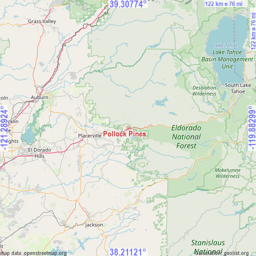
Pollock Pines GPS coordinates[2]
38° 45' 41.688" North, 120° 35' 9.996" West
| Map corner | latitude | longitude |
|---|---|---|
| Upper-left | 39.30774°, | -121.28924° |
| Center: | 38.76158°, | -120.58611° |
| Lower-right: | 38.21121°, | -119.88299° |
| Map W x H: | 121.9×121.9 km | = 75.7×75.7mi |
| max Lat: | 71.29058° ⇑56.9% North |
| Pollock Pines: | 38.76158° |
| min Lat: | ⇓43.1% South 19.06759° |
| min Long | Pollock Pines | max Long |
| -171.73463° | -120.58611° | -66.98998° |
| W 6.6%⇐ | ⇒93.4% E |
Elevation
Elevation of Pollock Pines is 1207 m = 3960 ft, and this is 912.2 m = 2993 ft above average elevation for this country.
| Max E: |
3189 m = 10463 ft | 5.4% |
| Pollock Pines | 1207 m 3960 ft | |
| Avg. | 294.8 m = 967 ft | |
Min E: |
-60 m = -197 ft | 94.6% |
See also: United States elevation on elevation.city.
Geographical zone
Pollock Pines is located in North temperate zone (between Tropic of Cancer and the Arctic Circle). Distance of this Northern Tropic circle is 1704 km =1058.8 mi to South.| Distance of | km | miles | from Pollock Pines |
|---|---|---|---|
| North Pole | 5697.2 | 3540.1 | to North |
| Arctic Circle | 3091.3 | 1920.8 | to North |
| Tropic Cancer | 1704 | 1058.8 | to South |
| Equator | 4309.9 | 2678 | to South |


Nearby cities:
15 places around Pollock Pines: (largest is in red/bold)
• Auburn Lake Trails
36 km =22.4 mi,  298°
298°
• Buckhorn
34.8 km =21.6 mi,  171°
171°
• Cameron Park
36.3 km =22.6 mi,  253°
253°
• Camino
8.1 km =5 mi, 251°
• Coloma
26.7 km =16.6 mi,  279°
279°
• Deer Park
22.4 km =13.9 mi, 246°
• Diamond Springs
21.2 km =13.2 mi, 249°
• Foresthill
35.1 km =21.8 mi,  325°
325°
• Georgetown
27.2 km =16.9 mi,  306°
306°
• Pine Grove
39.3 km =24.4 mi,  189°
189°
• Pioneer
36.7 km =22.8 mi,  178°
178°
• Placerville
18.8 km =11.7 mi,  259°
259°
• Plymouth
38.4 km =23.9 mi,  215°
215°
• Red Corral
38.9 km =24.2 mi, 182°
• Shingle Springs
31.4 km =19.5 mi, 250°
Sources, notices
• [Note1] Compared only with cities in United States existing in our database
• [Src1] Map data: © OpenStreetMap contributors (CC-BY-SA)
• [Src2] Other city data from geonames.org with taken over terms of usage.
• [Src3] Geographical zone / Annual Mean Temperature by Robert A. Rohde @ Wikipedia
