Clay geodata
Clay (California) is a populated place; located in United States in America/Los_Angeles (GMT-7) time zone. With population of 1,195 people, there are 15151 cities with bigger population in this country. Compared to other cities in United States, 59.7% of cities are located further ↑North; 93.9% of cities are located further →East and 83.8% of cities have higher elevation than Clay. Note1


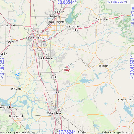
Clay GPS coordinates[2]
38° 20' 9.672" North, 121° 9' 33.804" West
| Map corner | latitude | longitude |
|---|---|---|
| Upper-left | 38.88544°, | -121.86252° |
| Center: | 38.33602°, | -121.15939° |
| Lower-right: | 37.7824°, | -120.45627° |
| Map W x H: | 122.6×122.6 km | = 76.2×76.2mi |
| max Lat: | 71.29058° ⇑59.7% North |
| Clay: | 38.33602° |
| min Lat: | ⇓40.3% South 19.06759° |
| min Long | Clay | max Long |
| -171.73463° | -121.15939° | -66.98998° |
| W 6.1%⇐ | ⇒93.9% E |
Elevation
Elevation of Clay is 32 m = 105 ft, and this is 262.8 m = 862 ft below average elevation for this country.
| Max E: |
3189 m = 10463 ft | 83.8% |
| Avg. | 294.8 m = 967 ft | |
| Clay | 32 m = 105 ft | |
Min E: |
-60 m = -197 ft | 16.2% |
See also: United States elevation on elevation.city.
Geographical zone
Clay is located in North temperate zone (between Tropic of Cancer and the Arctic Circle). Distance of this Northern Tropic circle is 1656.6 km =1029.4 mi to South.| Distance of | km | miles | from Clay |
|---|---|---|---|
| North Pole | 5744.5 | 3569.5 | to North |
| Arctic Circle | 3138.6 | 1950.2 | to North |
| Tropic Cancer | 1656.6 | 1029.4 | to South |
| Equator | 4262.6 | 2648.7 | to South |


Nearby cities:
15 places around Clay: (largest is in red/bold)
• Camanche North Shore
20.6 km =12.8 mi,  119°
119°
• Camanche Village
17.8 km =11.1 mi,  114°
114°
• Collierville
16.5 km =10.3 mi,  215°
215°
• Dogtown
14.9 km =9.3 mi,  155°
155°
• Elk Grove
20.2 km =12.6 mi,  293°
293°
• Galt
15.2 km =9.4 mi,  233°
233°
• Herald
8.7 km =5.4 mi,  238°
238°
• Ione
19.9 km =12.4 mi,  84°
84°
• Laguna
24.9 km =15.5 mi, 292°
• Lockeford
19.2 km =11.9 mi,  177°
177°
• Lodi
24.9 km =15.5 mi,  203°
203°
• Rancho Murieta
19.3 km =12 mi,  17°
17°
• Vineyard
21.7 km =13.5 mi,  311°
311°
• Wilton
13 km =8.1 mi, 310°
• Woodbridge
23.7 km =14.7 mi,  211°
211°
Sources, notices
• [Note1] Compared only with cities in United States existing in our database
• [Src1] Map data: © OpenStreetMap contributors (CC-BY-SA)
• [Src2] Other city data from geonames.org with taken over terms of usage.
• [Src3] Geographical zone / Annual Mean Temperature by Robert A. Rohde @ Wikipedia
