Roseland geodata
Roseland (California) is a section of populated place; located in United States in America/Los_Angeles (GMT-7) time zone. With population of 6,325 people, there are 6208 cities with bigger population in this country. Compared to other cities in United States, 59.2% of cities are located further ↑North; 97.3% of cities are located further →East and 80.9% of cities have higher elevation than Roseland. Note1


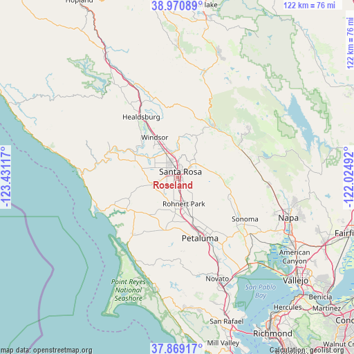
Roseland GPS coordinates[2]
38° 25' 19.668" North, 122° 43' 40.944" West
| Map corner | latitude | longitude |
|---|---|---|
| Upper-left | 38.97089°, | -123.43117° |
| Center: | 38.42213°, | -122.72804° |
| Lower-right: | 37.86917°, | -122.02492° |
| Map W x H: | 122.5×122.5 km | = 76.1×76.1mi |
| max Lat: | 71.29058° ⇑59.2% North |
| Roseland: | 38.42213° |
| min Lat: | ⇓40.8% South 19.06759° |
| min Long | Roseland | max Long |
| -171.73463° | -122.72804° | -66.98998° |
| W 2.7%⇐ | ⇒97.3% E |
Elevation
Elevation of Roseland is 43 m = 141 ft, and this is 251.8 m = 826 ft below average elevation for this country.
| Max E: |
3189 m = 10463 ft | 80.9% |
| Avg. | 294.8 m = 967 ft | |
| Roseland | 43 m = 141 ft | |
Min E: |
-60 m = -197 ft | 19.1% |
See also: United States elevation on elevation.city.
Geographical zone
Roseland is located in North temperate zone (between Tropic of Cancer and the Arctic Circle). Distance of this Northern Tropic circle is 1666.2 km =1035.3 mi to South.| Distance of | km | miles | from Roseland |
|---|---|---|---|
| North Pole | 5734.9 | 3563.5 | to North |
| Arctic Circle | 3129 | 1944.3 | to North |
| Tropic Cancer | 1666.2 | 1035.3 | to South |
| Equator | 4272.1 | 2654.6 | to South |


Nearby cities:
15 places around Roseland: (largest is in red/bold)
• Camp Meeker
20.2 km =12.6 mi,  270°
270°
• Cotati
10.7 km =6.6 mi,  170°
170°
• Eldridge
20.6 km =12.8 mi,  113°
113°
• Forestville
15.2 km =9.4 mi,  292°
292°
• Fulton
9 km =5.6 mi,  336°
336°
• Glen Ellen
18.9 km =11.7 mi, 109°
• Graton
12.4 km =7.7 mi,  277°
277°
• Kenwood
15.9 km =9.9 mi,  93°
93°
• Larkfield-Wikiup
10.3 km =6.4 mi,  348°
348°
• Occidental
19.3 km =12 mi, 265°
• Penngrove
14.6 km =9.1 mi,  158°
158°
• Rohnert Park
9.5 km =5.9 mi, 165°
• Santa Rosa
2.4 km =1.5 mi,  30°
30°
• Sebastopol
8.6 km =5.3 mi,  255°
255°
• Windsor
15.9 km =9.9 mi,  331°
331°
Sources, notices
• [Note1] Compared only with cities in United States existing in our database
• [Src1] Map data: © OpenStreetMap contributors (CC-BY-SA)
• [Src2] Other city data from geonames.org with taken over terms of usage.
• [Src3] Geographical zone / Annual Mean Temperature by Robert A. Rohde @ Wikipedia
