Larkfield-Wikiup geodata
Larkfield-Wikiup (California) is a populated place; located in United States in America/Los_Angeles (GMT-7) time zone. With population of 8,884 people, there are 4849 cities with bigger population in this country. Compared to other cities in United States, 58.7% of cities are located further ↑North; 97.3% of cities are located further →East and 70% of cities have higher elevation than Larkfield-Wikiup. Note1


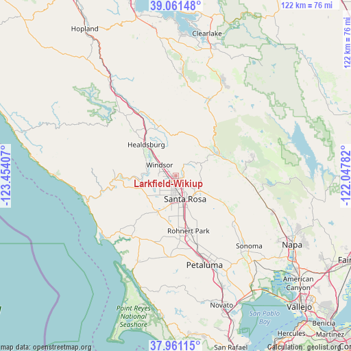
Larkfield-Wikiup GPS coordinates[2]
38° 30' 48.312" North, 122° 45' 3.384" West
| Map corner | latitude | longitude |
|---|---|---|
| Upper-left | 39.06148°, | -123.45407° |
| Center: | 38.51342°, | -122.75094° |
| Lower-right: | 37.96115°, | -122.04782° |
| Map W x H: | 122.3×122.3 km | = 76×76mi |
| max Lat: | 71.29058° ⇑58.7% North |
| Larkfield-Wikiup: | 38.51342° |
| min Lat: | ⇓41.3% South 19.06759° |
| min Long | Larkfield-Wikiu | max Long |
| -171.73463° | -122.75094° | -66.98998° |
| W 2.7%⇐ | ⇒97.3% E |
Elevation
Elevation of Larkfield-Wikiup is 101 m = 331 ft, and this is 193.8 m = 636 ft below average elevation for this country.
| Max E: |
3189 m = 10463 ft | 70% |
| Avg. | 294.8 m = 967 ft | |
| Larkfield-Wikiup | 101 m = 331 ft | |
Min E: |
-60 m = -197 ft | 30% |
See also: United States elevation on elevation.city.
Geographical zone
Larkfield-Wikiup is located in North temperate zone (between Tropic of Cancer and the Arctic Circle). Distance of this Northern Tropic circle is 1676.4 km =1041.7 mi to South.| Distance of | km | miles | from Larkfield-Wikiup |
|---|---|---|---|
| North Pole | 5724.8 | 3557.2 | to North |
| Arctic Circle | 3118.9 | 1938 | to North |
| Tropic Cancer | 1676.4 | 1041.7 | to South |
| Equator | 4282.3 | 2660.9 | to South |


Nearby cities:
15 places around Larkfield-Wikiup: (largest is in red/bold)
• Calistoga
16.6 km =10.3 mi,  63°
63°
• Camp Meeker
20.6 km =12.8 mi,  241°
241°
• Cotati
21.1 km =13.1 mi,  169°
169°
• Forestville
12.9 km =8 mi,  249°
249°
• Fulton
2.5 km =1.6 mi,  221°
221°
• Graton
13.4 km =8.3 mi,  230°
230°
• Guerneville
21.4 km =13.3 mi,  266°
266°
• Healdsburg
14.9 km =9.3 mi,  316°
316°
• Kenwood
21 km =13 mi,  121°
121°
• Occidental
20.8 km =12.9 mi, 235°
• Rohnert Park
19.8 km =12.3 mi, 167°
• Roseland
10.3 km =6.4 mi, 168°
• Santa Rosa
8.7 km =5.4 mi,  158°
158°
• Sebastopol
13.9 km =8.6 mi,  207°
207°
• Windsor
6.8 km =4.2 mi,  303°
303°
Sources, notices
• [Note1] Compared only with cities in United States existing in our database
• [Src1] Map data: © OpenStreetMap contributors (CC-BY-SA)
• [Src2] Other city data from geonames.org with taken over terms of usage.
• [Src3] Geographical zone / Annual Mean Temperature by Robert A. Rohde @ Wikipedia
