Montebello geodata
Montebello (California) is a populated place; located in United States in America/Los_Angeles (GMT-7) time zone. With population of 63,921 people, there are 679 cities with bigger population in this country. Compared to other cities in United States, 80.2% of cities are located further ↑North; 91% of cities are located further →East and 76% of cities have higher elevation than Montebello. Note1


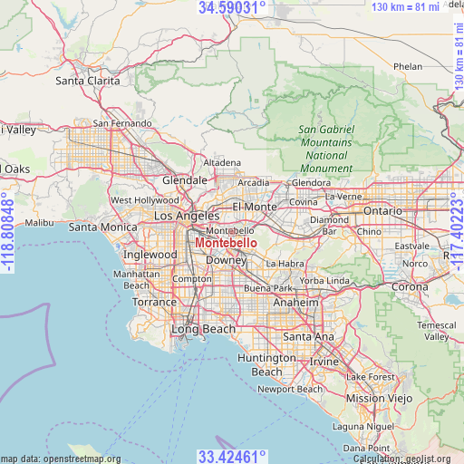
Montebello GPS coordinates[2]
34° 0' 34.056" North, 118° 6' 19.26" West
| Map corner | latitude | longitude |
|---|---|---|
| Upper-left | 34.59031°, | -118.80848° |
| Center: | 34.00946°, | -118.10535° |
| Lower-right: | 33.42461°, | -117.40223° |
| Map W x H: | 129.6×129.6 km | = 80.5×80.5mi |
| max Lat: | 71.29058° ⇑80.2% North |
| Montebello: | 34.00946° |
| min Lat: | ⇓19.8% South 19.06759° |
| min Long | Montebello | max Long |
| -171.73463° | -118.10535° | -66.98998° |
| W 9%⇐ | ⇒91% E |
Elevation
Elevation of Montebello is 66 m = 217 ft, and this is 228.8 m = 751 ft below average elevation for this country.
| Max E: |
3189 m = 10463 ft | 76% |
| Avg. | 294.8 m = 967 ft | |
| Montebello | 66 m = 217 ft | |
Min E: |
-60 m = -197 ft | 24% |
See also: Montebello elevation on elevation.city.
Geographical zone
Montebello is located in North temperate zone (between Tropic of Cancer and the Arctic Circle). Distance of this Northern Tropic circle is 1175.6 km =730.5 mi to South.| Distance of | km | miles | from Montebello |
|---|---|---|---|
| North Pole | 6225.6 | 3868.4 | to North |
| Arctic Circle | 3619.7 | 2249.2 | to North |
| Tropic Cancer | 1175.6 | 730.5 | to South |
| Equator | 3781.5 | 2349.7 | to South |


Nearby cities:
15 places around Montebello: (largest is in red/bold)
• Bell
8.3 km =5.2 mi,  244°
244°
• Bell Gardens
6.5 km =4 mi,  220°
220°
• Belvedere
6.8 km =4.2 mi,  300°
300°
• Commerce
5.1 km =3.2 mi,  258°
258°
• Downey
8.1 km =5 mi,  198°
198°
• East Los Angeles
6.4 km =4 mi,  284°
284°
• Maywood
7.8 km =4.8 mi,  251°
251°
• Monterey Park
6.1 km =3.8 mi,  344°
344°
• Pico Rivera
3 km =1.9 mi,  164°
164°
• Rosemead
8.5 km =5.3 mi,  20°
20°
• Santa Fe Springs
7.2 km =4.5 mi,  165°
165°
• South El Monte
7.2 km =4.5 mi,  48°
48°
• South San Gabriel
4.5 km =2.8 mi,  12°
12°
• West Whittier-Los Nietos
5 km =3.1 mi,  138°
138°
• Whittier
7.5 km =4.7 mi,  116°
116°
Sources, notices
• [Note1] Compared only with cities in United States existing in our database
• [Src1] Map data: © OpenStreetMap contributors (CC-BY-SA)
• [Src2] Other city data from geonames.org with taken over terms of usage.
• [Src3] Geographical zone / Annual Mean Temperature by Robert A. Rohde @ Wikipedia
