Shandon geodata
Shandon (California) is a populated place; located in United States in America/Los_Angeles (GMT-7) time zone. With population of 1,295 people, there are 14610 cities with bigger population in this country. Compared to other cities in United States, 71.9% of cities are located further ↑North; 93.2% of cities are located further →East and 75.7% of cities have lower elevation than Shandon. Note1


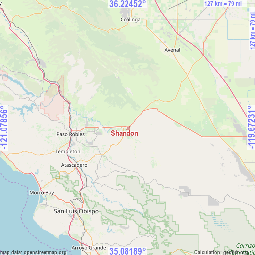
Shandon GPS coordinates[2]
35° 39' 18.9" North, 120° 22' 31.548" West
| Map corner | latitude | longitude |
|---|---|---|
| Upper-left | 36.22452°, | -121.07856° |
| Center: | 35.65525°, | -120.37543° |
| Lower-right: | 35.08189°, | -119.67231° |
| Map W x H: | 127×127 km | = 78.9×78.9mi |
| max Lat: | 71.29058° ⇑71.9% North |
| Shandon: | 35.65525° |
| min Lat: | ⇓28.1% South 19.06759° |
| min Long | Shandon | max Long |
| -171.73463° | -120.37543° | -66.98998° |
| W 6.8%⇐ | ⇒93.2% E |
Elevation
Elevation of Shandon is 318 m = 1043 ft, and this is 23.2 m = 76 ft above average elevation for this country.
| Max E: |
3189 m = 10463 ft | 24.3% |
| Shandon | 318 m 1043 ft | |
| Avg. | 294.8 m = 967 ft | |
Min E: |
-60 m = -197 ft | 75.7% |
See also: United States elevation on elevation.city.
Geographical zone
Shandon is located in North temperate zone (between Tropic of Cancer and the Arctic Circle). Distance of this Northern Tropic circle is 1358.6 km =844.2 mi to South.| Distance of | km | miles | from Shandon |
|---|---|---|---|
| North Pole | 6042.6 | 3754.7 | to North |
| Arctic Circle | 3436.7 | 2135.5 | to North |
| Tropic Cancer | 1358.6 | 844.2 | to South |
| Equator | 3964.5 | 2463.4 | to South |


Nearby cities:
15 places around Shandon: (largest is in red/bold)
• Atascadero
32.5 km =20.2 mi,  235°
235°
• Avenal
44.7 km =27.8 mi,  29°
29°
• Cayucos
52.4 km =32.6 mi, 243°
• Coalinga
53.9 km =33.5 mi,  1°
1°
• Kettleman City
54.1 km =33.6 mi,  43°
43°
• Lake Nacimiento
46.3 km =28.8 mi,  280°
280°
• Los Osos
56.4 km =35 mi,  227°
227°
• Lost Hills
61.7 km =38.3 mi,  94°
94°
• Morro Bay
53.7 km =33.4 mi, 233°
• Paso Robles
28.7 km =17.8 mi,  263°
263°
• Pismo Beach
61.9 km =38.5 mi,  202°
202°
• San Luis Obispo
48.8 km =30.3 mi,  211°
211°
• San Miguel
30.9 km =19.2 mi,  290°
290°
• Santa Margarita
36.3 km =22.6 mi,  215°
215°
• Templeton
32.1 km =19.9 mi,  248°
248°
Sources, notices
• [Note1] Compared only with cities in United States existing in our database
• [Src1] Map data: © OpenStreetMap contributors (CC-BY-SA)
• [Src2] Other city data from geonames.org with taken over terms of usage.
• [Src3] Geographical zone / Annual Mean Temperature by Robert A. Rohde @ Wikipedia
