Coalinga geodata
Coalinga (California) is a populated place; located in United States in America/Los_Angeles (GMT-7) time zone. With population of 16,564 people, there are 2966 cities with bigger population in this country. Compared to other cities in United States, 69.7% of cities are located further ↑North; 93.2% of cities are located further →East and 52.2% of cities have lower elevation than Coalinga. Note1


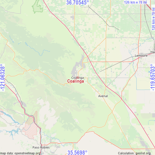
Coalinga GPS coordinates[2]
36° 8' 22.848" North, 120° 21' 36.54" West
| Map corner | latitude | longitude |
|---|---|---|
| Upper-left | 36.70545°, | -121.06328° |
| Center: | 36.13968°, | -120.36015° |
| Lower-right: | 35.5698°, | -119.65703° |
| Map W x H: | 126.3×126.3 km | = 78.5×78.5mi |
| max Lat: | 71.29058° ⇑69.7% North |
| Coalinga: | 36.13968° |
| min Lat: | ⇓30.3% South 19.06759° |
| min Long | Coalinga | max Long |
| -171.73463° | -120.36015° | -66.98998° |
| W 6.8%⇐ | ⇒93.2% E |
Elevation
Elevation of Coalinga is 207 m = 679 ft, and this is 87.8 m = 288 ft below average elevation for this country.
| Max E: |
3189 m = 10463 ft | 47.8% |
| Avg. | 294.8 m = 967 ft | |
| Coalinga | 207 m = 679 ft | |
Min E: |
-60 m = -197 ft | 52.2% |
See also: United States elevation on elevation.city.
Geographical zone
Coalinga is located in North temperate zone (between Tropic of Cancer and the Arctic Circle). Distance of this Northern Tropic circle is 1412.4 km =877.6 mi to South.| Distance of | km | miles | from Coalinga |
|---|---|---|---|
| North Pole | 5988.7 | 3721.2 | to North |
| Arctic Circle | 3382.8 | 2102 | to North |
| Tropic Cancer | 1412.4 | 877.6 | to South |
| Equator | 4018.4 | 2496.9 | to South |


Nearby cities:
15 places around Coalinga: (largest is in red/bold)
• Armona
61.6 km =38.3 mi,  71°
71°
• Avenal
25.7 km =16 mi,  125°
125°
• Huron
24.1 km =15 mi, 73°
• Kettleman City
38.7 km =24 mi,  112°
112°
• Lanare
50.3 km =31.3 mi,  49°
49°
• Lemoore
54.8 km =34.1 mi, 70°
• Lemoore Station
43.1 km =26.8 mi, 71°
• Paso Robles
64.4 km =40 mi,  207°
207°
• Riverdale
55.3 km =34.4 mi, 54°
• San Ardo
50.7 km =31.5 mi,  254°
254°
• San Joaquin
54.1 km =33.6 mi,  16°
16°
• San Miguel
52.6 km =32.7 mi,  215°
215°
• Shandon
53.9 km =33.5 mi,  181°
181°
• Stratford
48.5 km =30.1 mi,  83°
83°
• Tranquillity
57.4 km =35.7 mi,  9°
9°
Sources, notices
• [Note1] Compared only with cities in United States existing in our database
• [Src1] Map data: © OpenStreetMap contributors (CC-BY-SA)
• [Src2] Other city data from geonames.org with taken over terms of usage.
• [Src3] Geographical zone / Annual Mean Temperature by Robert A. Rohde @ Wikipedia
