Sunland geodata
Sunland (California) is a section of populated place; located in United States in America/Los_Angeles (GMT-7) time zone. With population of 15,316 people, there are 3183 cities with bigger population in this country. Compared to other cities in United States, 78.6% of cities are located further ↑North; 91.3% of cities are located further →East and 86.8% of cities have lower elevation than Sunland. Note1


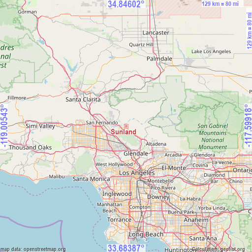
Sunland GPS coordinates[2]
34° 16' 1.02" North, 118° 18' 8.28" West
| Map corner | latitude | longitude |
|---|---|---|
| Upper-left | 34.84602°, | -119.00543° |
| Center: | 34.26695°, | -118.3023° |
| Lower-right: | 33.68387°, | -117.59918° |
| Map W x H: | 129.2×129.2 km | = 80.3×80.3mi |
| max Lat: | 71.29058° ⇑78.6% North |
| Sunland: | 34.26695° |
| min Lat: | ⇓21.4% South 19.06759° |
| min Long | Sunland | max Long |
| -171.73463° | -118.3023° | -66.98998° |
| W 8.7%⇐ | ⇒91.3% E |
Elevation
Elevation of Sunland is 464 m = 1522 ft, and this is 169.2 m = 555 ft above average elevation for this country.
| Max E: |
3189 m = 10463 ft | 13.2% |
| Sunland | 464 m 1522 ft | |
| Avg. | 294.8 m = 967 ft | |
Min E: |
-60 m = -197 ft | 86.8% |
See also: United States elevation on elevation.city.
Geographical zone
Sunland is located in North temperate zone (between Tropic of Cancer and the Arctic Circle). Distance of this Northern Tropic circle is 1204.2 km =748.3 mi to South.| Distance of | km | miles | from Sunland |
|---|---|---|---|
| North Pole | 6196.9 | 3850.6 | to North |
| Arctic Circle | 3591 | 2231.3 | to North |
| Tropic Cancer | 1204.2 | 748.3 | to South |
| Equator | 3810.1 | 2367.5 | to South |


Nearby cities:
15 places around Sunland: (largest is in red/bold)
• Altadena
17.9 km =11.1 mi,  118°
118°
• Burbank
9.6 km =6 mi,  183°
183°
• Glendale
14.5 km =9 mi,  162°
162°
• La Cañada Flintridge
12.9 km =8 mi,  125°
125°
• La Crescenta-Montrose
7.3 km =4.5 mi, 122°
• North Hills
17.1 km =10.6 mi,  258°
258°
• North Hollywood
12.7 km =7.9 mi,  213°
213°
• San Fernando
12.7 km =7.9 mi,  277°
277°
• Shadow Hills
4.6 km =2.9 mi, 263°
• Sherman Oaks
18.7 km =11.6 mi,  226°
226°
• Studio City
15.8 km =9.8 mi, 213°
• Tujunga
2.1 km =1.3 mi,  142°
142°
• Universal City
15 km =9.3 mi,  198°
198°
• Valley Glen
16 km =9.9 mi,  237°
237°
• Van Nuys
16.2 km =10.1 mi, 236°
Sources, notices
• [Note1] Compared only with cities in United States existing in our database
• [Src1] Map data: © OpenStreetMap contributors (CC-BY-SA)
• [Src2] Other city data from geonames.org with taken over terms of usage.
• [Src3] Geographical zone / Annual Mean Temperature by Robert A. Rohde @ Wikipedia
