Glendale geodata
Glendale (California) is a populated place; located in United States in America/Los_Angeles (GMT-7) time zone. With population of 201,020 people, there are 126 cities with bigger population in this country. Compared to other cities in United States, 79.3% of cities are located further ↑North; 91.2% of cities are located further →East and 58.8% of cities have higher elevation than Glendale. Note1


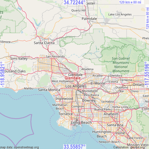
Glendale GPS coordinates[2]
34° 8' 33.036" North, 118° 15' 18.288" West
| Map corner | latitude | longitude |
|---|---|---|
| Upper-left | 34.72244°, | -118.95821° |
| Center: | 34.14251°, | -118.25508° |
| Lower-right: | 33.55857°, | -117.55196° |
| Map W x H: | 129.4×129.4 km | = 80.4×80.4mi |
| max Lat: | 71.29058° ⇑79.3% North |
| Glendale: | 34.14251° |
| min Lat: | ⇓20.7% South 19.06759° |
| min Long | Glendale | max Long |
| -171.73463° | -118.25508° | -66.98998° |
| W 8.8%⇐ | ⇒91.2% E |
Elevation
Elevation of Glendale is 161 m = 528 ft, and this is 133.8 m = 439 ft below average elevation for this country.
| Max E: |
3189 m = 10463 ft | 58.8% |
| Avg. | 294.8 m = 967 ft | |
| Glendale | 161 m = 528 ft | |
Min E: |
-60 m = -197 ft | 41.2% |
See also: Glendale elevation on elevation.city.
Geographical zone
Glendale is located in North temperate zone (between Tropic of Cancer and the Arctic Circle). Distance of this Northern Tropic circle is 1190.4 km =739.7 mi to South.| Distance of | km | miles | from Glendale |
|---|---|---|---|
| North Pole | 6210.8 | 3859.2 | to North |
| Arctic Circle | 3604.9 | 2240 | to North |
| Tropic Cancer | 1190.4 | 739.7 | to South |
| Equator | 3796.3 | 2358.9 | to South |


Nearby cities:
15 places around Glendale: (largest is in red/bold)
• Altadena
12.5 km =7.8 mi,  65°
65°
• Burbank
6.5 km =4 mi,  310°
310°
• Echo Park
7.2 km =4.5 mi,  184°
184°
• Hollywood
8.2 km =5.1 mi,  233°
233°
• Koreatown
10.3 km =6.4 mi,  204°
204°
• La Cañada Flintridge
8.8 km =5.5 mi,  44°
44°
• La Crescenta-Montrose
10.1 km =6.3 mi,  10°
10°
• Los Angeles
10.1 km =6.3 mi,  174°
174°
• North Hollywood
11.9 km =7.4 mi,  286°
286°
• Pasadena
10.2 km =6.3 mi,  86°
86°
• Silver Lake
6.4 km =4 mi,  192°
192°
• South Pasadena
10.1 km =6.3 mi,  106°
106°
• Tujunga
12.6 km =7.8 mi,  345°
345°
• Universal City
9.1 km =5.7 mi,  267°
267°
• West Hollywood
11.4 km =7.1 mi,  239°
239°
Sources, notices
• [Note1] Compared only with cities in United States existing in our database
• [Src1] Map data: © OpenStreetMap contributors (CC-BY-SA)
• [Src2] Other city data from geonames.org with taken over terms of usage.
• [Src3] Geographical zone / Annual Mean Temperature by Robert A. Rohde @ Wikipedia
