La Crescenta-Montrose geodata
La Crescenta-Montrose (California) is a populated place; located in United States in America/Los_Angeles (GMT-7) time zone. With population of 19,653 people, there are 2557 cities with bigger population in this country. Compared to other cities in United States, 78.8% of cities are located further ↑North; 91.2% of cities are located further →East and 89.1% of cities have lower elevation than La Crescenta-Montrose. Note1


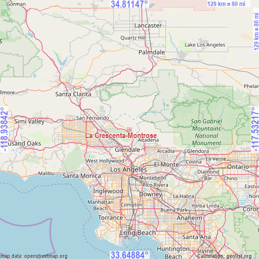
La Crescenta-Montrose GPS coordinates[2]
34° 13' 55.776" North, 118° 14' 7.044" West
| Map corner | latitude | longitude |
|---|---|---|
| Upper-left | 34.81147°, | -118.93842° |
| Center: | 34.23216°, | -118.23529° |
| Lower-right: | 33.64884°, | -117.53217° |
| Map W x H: | 129.3×129.3 km | = 80.3×80.3mi |
| max Lat: | 71.29058° ⇑78.8% North |
| La Crescenta-Montrose: | 34.23216° |
| min Lat: | ⇓21.2% South 19.06759° |
| min Long | La Crescenta-Mo | max Long |
| -171.73463° | -118.23529° | -66.98998° |
| W 8.8%⇐ | ⇒91.2% E |
Elevation
Elevation of La Crescenta-Montrose is 565 m = 1854 ft, and this is 270.2 m = 886 ft above average elevation for this country.
| Max E: |
3189 m = 10463 ft | 10.9% |
| La Crescenta-Montrose | 565 m 1854 ft | |
| Avg. | 294.8 m = 967 ft | |
Min E: |
-60 m = -197 ft | 89.1% |
See also: United States elevation on elevation.city.
Geographical zone
La Crescenta-Montrose is located in North temperate zone (between Tropic of Cancer and the Arctic Circle). Distance of this Northern Tropic circle is 1200.3 km =745.8 mi to South.| Distance of | km | miles | from La Crescenta-Montrose |
|---|---|---|---|
| North Pole | 6200.8 | 3853 | to North |
| Arctic Circle | 3594.9 | 2233.8 | to North |
| Tropic Cancer | 1200.3 | 745.8 | to South |
| Equator | 3806.3 | 2365.1 | to South |


Nearby cities:
15 places around La Crescenta-Montrose: (largest is in red/bold)
• Altadena
10.7 km =6.6 mi,  116°
116°
• Burbank
8.9 km =5.5 mi,  229°
229°
• Echo Park
17.3 km =10.7 mi,  187°
187°
• Glendale
10.1 km =6.3 mi, 190°
• Hollywood
17.1 km =10.6 mi,  209°
209°
• La Cañada Flintridge
5.7 km =3.5 mi,  130°
130°
• North Hollywood
14.8 km =9.2 mi,  243°
243°
• Pasadena
12.6 km =7.8 mi,  138°
138°
• San Marino
17.1 km =10.6 mi, 136°
• Shadow Hills
11.2 km =7 mi,  287°
287°
• Silver Lake
16.5 km =10.3 mi, 191°
• South Pasadena
15.1 km =9.4 mi,  148°
148°
• Sunland
7.3 km =4.5 mi,  302°
302°
• Tujunga
5.4 km =3.4 mi, 294°
• Universal City
15 km =9.3 mi, 226°
Sources, notices
• [Note1] Compared only with cities in United States existing in our database
• [Src1] Map data: © OpenStreetMap contributors (CC-BY-SA)
• [Src2] Other city data from geonames.org with taken over terms of usage.
• [Src3] Geographical zone / Annual Mean Temperature by Robert A. Rohde @ Wikipedia
