Tuolumne City geodata
Tuolumne City (California) is a populated place; located in United States in America/Los_Angeles (GMT-7) time zone. With population of 1,779 people, there are 12629 cities with bigger population in this country. Compared to other cities in United States, 61.9% of cities are located further ↑North; 93% of cities are located further →East and 91.9% of cities have lower elevation than Tuolumne City. Note1


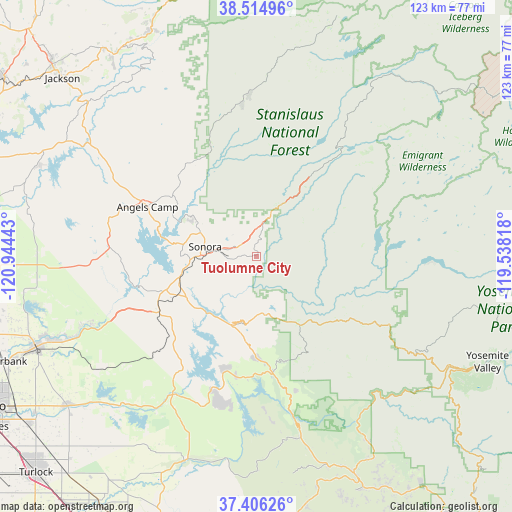
Tuolumne City GPS coordinates[2]
37° 57' 45.72" North, 120° 14' 28.68" West
| Map corner | latitude | longitude |
|---|---|---|
| Upper-left | 38.51496°, | -120.94443° |
| Center: | 37.9627°, | -120.2413° |
| Lower-right: | 37.40626°, | -119.53818° |
| Map W x H: | 123.3×123.3 km | = 76.6×76.6mi |
| max Lat: | 71.29058° ⇑61.9% North |
| Tuolumne City: | 37.9627° |
| min Lat: | ⇓38.1% South 19.06759° |
| min Long | Tuolumne City | max Long |
| -171.73463° | -120.2413° | -66.98998° |
| W 7%⇐ | ⇒93% E |
Elevation
Elevation of Tuolumne City is 786 m = 2579 ft, and this is 491.2 m = 1612 ft above average elevation for this country.
| Max E: |
3189 m = 10463 ft | 8.1% |
| Tuolumne City | 786 m 2579 ft | |
| Avg. | 294.8 m = 967 ft | |
Min E: |
-60 m = -197 ft | 91.9% |
See also: United States elevation on elevation.city.
Geographical zone
Tuolumne City is located in North temperate zone (between Tropic of Cancer and the Arctic Circle). Distance of this Northern Tropic circle is 1615.1 km =1003.6 mi to South.| Distance of | km | miles | from Tuolumne City |
|---|---|---|---|
| North Pole | 5786 | 3595.3 | to North |
| Arctic Circle | 3180.1 | 1976 | to North |
| Tropic Cancer | 1615.1 | 1003.6 | to South |
| Equator | 4221.1 | 2622.9 | to South |


Nearby cities:
15 places around Tuolumne City: (largest is in red/bold)
• Cedar Ridge
11.9 km =7.4 mi,  344°
344°
• Columbia
16.2 km =10.1 mi,  300°
300°
• East Sonora
10.6 km =6.6 mi,  279°
279°
• Forest Meadows
27.1 km =16.8 mi,  327°
327°
• Greeley Hill
26.1 km =16.2 mi,  158°
158°
• Groveland
13.9 km =8.6 mi,  176°
176°
• Jamestown
15.9 km =9.9 mi,  266°
266°
• Mi-Wuk Village
12.5 km =7.8 mi,  23°
23°
• Mono Vista
4.6 km =2.9 mi, 327°
• Murphys
27.4 km =17 mi,  315°
315°
• Phoenix Lake
7.5 km =4.7 mi,  309°
309°
• Sonora
12.6 km =7.8 mi, 280°
• Soulsbyville
3.1 km =1.9 mi, 321°
• Tuttletown
19.4 km =12.1 mi, 279°
• Twain Harte
8.6 km =5.3 mi,  5°
5°
Sources, notices
• [Note1] Compared only with cities in United States existing in our database
• [Src1] Map data: © OpenStreetMap contributors (CC-BY-SA)
• [Src2] Other city data from geonames.org with taken over terms of usage.
• [Src3] Geographical zone / Annual Mean Temperature by Robert A. Rohde @ Wikipedia
