Ukiah geodata
Ukiah (California) is a seat of a second-order administrative division; located in United States in America/Los_Angeles (GMT-7) time zone. With population of 15,917 people, there are 3078 cities with bigger population in this country. Compared to other cities in United States, 53.4% of cities are located further ↑North; 98.1% of cities are located further →East and 51.1% of cities have higher elevation than Ukiah. Note1


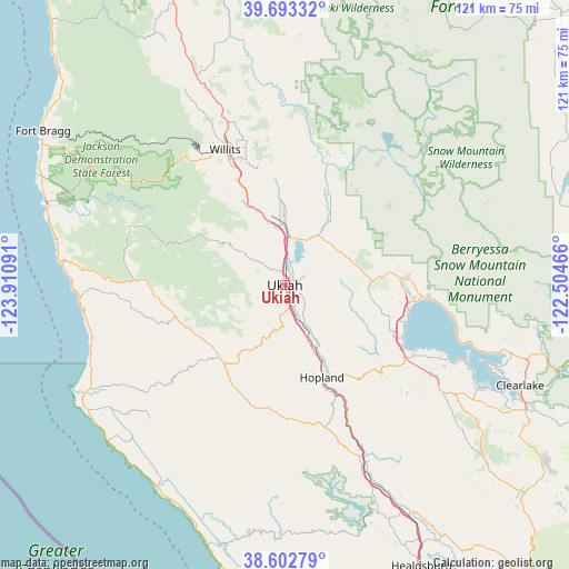
Ukiah GPS coordinates[2]
39° 9' 0.612" North, 123° 12' 28.008" West
| Map corner | latitude | longitude |
|---|---|---|
| Upper-left | 39.69332°, | -123.91091° |
| Center: | 39.15017°, | -123.20778° |
| Lower-right: | 38.60279°, | -122.50466° |
| Map W x H: | 121.3×121.3 km | = 75.4×75.4mi |
| max Lat: | 71.29058° ⇑53.4% North |
| Ukiah: | 39.15017° |
| min Lat: | ⇓46.6% South 19.06759° |
| min Long | Ukiah | max Long |
| -171.73463° | -123.20778° | -66.98998° |
| W 1.9%⇐ | ⇒98.1% E |
Elevation
Elevation of Ukiah is 194 m = 636 ft, and this is 100.8 m = 331 ft below average elevation for this country.
| Max E: |
3189 m = 10463 ft | 51.1% |
| Avg. | 294.8 m = 967 ft | |
| Ukiah | 194 m = 636 ft | |
Min E: |
-60 m = -197 ft | 48.9% |
See also: United States elevation on elevation.city.
Geographical zone
Ukiah is located in North temperate zone (between Tropic of Cancer and the Arctic Circle). Distance of this Northern Tropic circle is 1747.2 km =1085.7 mi to South.| Distance of | km | miles | from Ukiah |
|---|---|---|---|
| North Pole | 5654 | 3513.2 | to North |
| Arctic Circle | 3048.1 | 1894 | to North |
| Tropic Cancer | 1747.2 | 1085.7 | to South |
| Equator | 4353.1 | 2704.9 | to South |


Nearby cities:
15 places around Ukiah: (largest is in red/bold)
• Boonville
20.8 km =12.9 mi,  221°
221°
• Brooktrails
36 km =22.4 mi,  334°
334°
• Calpella
9.3 km =5.8 mi,  2°
2°
• Hopland
21.2 km =13.2 mi,  158°
158°
• Kelseyville
37.1 km =23.1 mi,  121°
121°
• Lakeport
27.9 km =17.3 mi, 115°
• Lucerne
36.1 km =22.4 mi,  100°
100°
• Nice
31.1 km =19.3 mi, 95°
• North Lakeport
27 km =16.8 mi, 104°
• Potter Valley
20.8 km =12.9 mi,  23°
23°
• Redwood Valley
12.8 km =8 mi, 1°
• Soda Bay
39.8 km =24.7 mi,  114°
114°
• Talmage
3.9 km =2.4 mi, 118°
• Upper Lake
25.7 km =16 mi,  86°
86°
• Willits
31.5 km =19.6 mi,  336°
336°
Sources, notices
• [Note1] Compared only with cities in United States existing in our database
• [Src1] Map data: © OpenStreetMap contributors (CC-BY-SA)
• [Src2] Other city data from geonames.org with taken over terms of usage.
• [Src3] Geographical zone / Annual Mean Temperature by Robert A. Rohde @ Wikipedia
