Westminster geodata
Westminster (California) is a populated place; located in United States in America/Los_Angeles (GMT-7) time zone. With population of 92,114 people, there are 400 cities with bigger population in this country. Compared to other cities in United States, 81.7% of cities are located further ↑North; 90.9% of cities are located further →East and 91% of cities have higher elevation than Westminster. Note1


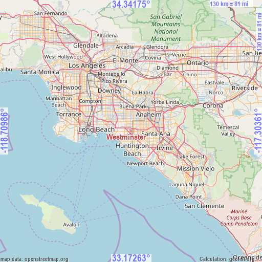
Westminster GPS coordinates[2]
33° 45' 33.048" North, 118° 0' 24.228" West
| Map corner | latitude | longitude |
|---|---|---|
| Upper-left | 34.34175°, | -118.70986° |
| Center: | 33.75918°, | -118.00673° |
| Lower-right: | 33.17263°, | -117.30361° |
| Map W x H: | 130×130 km | = 80.8×80.8mi |
| max Lat: | 71.29058° ⇑81.7% North |
| Westminster: | 33.75918° |
| min Lat: | ⇓18.3% South 19.06759° |
| min Long | Westminster | max Long |
| -171.73463° | -118.00673° | -66.98998° |
| W 9.1%⇐ | ⇒90.9% E |
Elevation
Elevation of Westminster is 14 m = 46 ft, and this is 280.8 m = 921 ft below average elevation for this country.
| Max E: |
3189 m = 10463 ft | 91% |
| Avg. | 294.8 m = 967 ft | |
| Westminster | 14 m = 46 ft | |
Min E: |
-60 m = -197 ft | 9% |
See also: Westminster elevation on elevation.city.
Geographical zone
Westminster is located in North temperate zone (between Tropic of Cancer and the Arctic Circle). Distance of this Northern Tropic circle is 1147.7 km =713.1 mi to South.| Distance of | km | miles | from Westminster |
|---|---|---|---|
| North Pole | 6253.4 | 3885.7 | to North |
| Arctic Circle | 3647.5 | 2266.5 | to North |
| Tropic Cancer | 1147.7 | 713.1 | to South |
| Equator | 3753.7 | 2332.4 | to South |


Nearby cities:
15 places around Westminster: (largest is in red/bold)
• Anaheim
12 km =7.5 mi,  45°
45°
• Buena Park
12.1 km =7.5 mi,  3°
3°
• Cerritos
12.3 km =7.6 mi,  334°
334°
• Cypress
7 km =4.3 mi,  336°
336°
• Fountain Valley
7.4 km =4.6 mi,  138°
138°
• Garden Grove
6.3 km =3.9 mi,  74°
74°
• Hawaiian Gardens
10.1 km =6.3 mi,  322°
322°
• Huntington Beach
11 km =6.8 mi,  176°
176°
• La Palma
10.4 km =6.5 mi, 339°
• Los Alamitos
7.8 km =4.8 mi,  308°
308°
• Midway City
2.3 km =1.4 mi,  134°
134°
• Rossmoor
7.8 km =4.8 mi,  292°
292°
• Seal Beach
9.3 km =5.8 mi,  257°
257°
• Stanton
5 km =3.1 mi,  14°
14°
• Sunset Beach
7.5 km =4.7 mi,  230°
230°
Sources, notices
• [Note1] Compared only with cities in United States existing in our database
• [Src1] Map data: © OpenStreetMap contributors (CC-BY-SA)
• [Src2] Other city data from geonames.org with taken over terms of usage.
• [Src3] Geographical zone / Annual Mean Temperature by Robert A. Rohde @ Wikipedia
