Cerritos geodata
Cerritos (California) is a populated place; located in United States in America/Los_Angeles (GMT-7) time zone. With population of 49,975 people, there are 951 cities with bigger population in this country. Compared to other cities in United States, 81.2% of cities are located further ↑North; 91% of cities are located further →East and 88.6% of cities have higher elevation than Cerritos. Note1


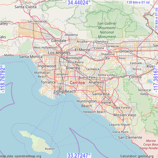
Cerritos GPS coordinates[2]
33° 51' 30.06" North, 118° 3' 53.244" West
| Map corner | latitude | longitude |
|---|---|---|
| Upper-left | 34.44024°, | -118.76792° |
| Center: | 33.85835°, | -118.06479° |
| Lower-right: | 33.27247°, | -117.36167° |
| Map W x H: | 129.8×129.8 km | = 80.7×80.7mi |
| max Lat: | 71.29058° ⇑81.2% North |
| Cerritos: | 33.85835° |
| min Lat: | ⇓18.8% South 19.06759° |
| min Long | Cerritos | max Long |
| -171.73463° | -118.06479° | -66.98998° |
| W 9%⇐ | ⇒91% E |
Elevation
Elevation of Cerritos is 19 m = 62 ft, and this is 275.8 m = 905 ft below average elevation for this country.
| Max E: |
3189 m = 10463 ft | 88.6% |
| Avg. | 294.8 m = 967 ft | |
| Cerritos | 19 m = 62 ft | |
Min E: |
-60 m = -197 ft | 11.4% |
See also: Cerritos elevation on elevation.city.
Geographical zone
Cerritos is located in North temperate zone (between Tropic of Cancer and the Arctic Circle). Distance of this Northern Tropic circle is 1158.8 km =720 mi to South.| Distance of | km | miles | from Cerritos |
|---|---|---|---|
| North Pole | 6242.4 | 3878.8 | to North |
| Arctic Circle | 3636.5 | 2259.6 | to North |
| Tropic Cancer | 1158.8 | 720 | to South |
| Equator | 3764.7 | 2339.3 | to South |


Nearby cities:
15 places around Cerritos: (largest is in red/bold)
• Artesia
1.9 km =1.2 mi,  296°
296°
• Bellflower
5.5 km =3.4 mi, 298°
• Buena Park
6.2 km =3.9 mi,  80°
80°
• Cypress
5.3 km =3.3 mi,  151°
151°
• East La Mirada
10.2 km =6.3 mi,  43°
43°
• Hawaiian Gardens
3.1 km =1.9 mi,  193°
193°
• La Mirada
8.2 km =5.1 mi, 36°
• La Palma
2.1 km =1.3 mi,  128°
128°
• Lakewood
6.4 km =4 mi,  265°
265°
• Los Alamitos
6.2 km =3.9 mi, 186°
• Norwalk
5.1 km =3.2 mi,  342°
342°
• Paramount
9.4 km =5.8 mi,  291°
291°
• Rossmoor
8.3 km =5.2 mi, 193°
• Santa Fe Springs
10.1 km =6.3 mi,  349°
349°
• Stanton
9.1 km =5.7 mi, 133°
Sources, notices
• [Note1] Compared only with cities in United States existing in our database
• [Src1] Map data: © OpenStreetMap contributors (CC-BY-SA)
• [Src2] Other city data from geonames.org with taken over terms of usage.
• [Src3] Geographical zone / Annual Mean Temperature by Robert A. Rohde @ Wikipedia
