Wildomar geodata
Wildomar (California) is a populated place; located in United States in America/Los_Angeles (GMT-7) time zone. With population of 35,632 people, there are 1382 cities with bigger population in this country. Compared to other cities in United States, 82.7% of cities are located further ↑North; 90.2% of cities are located further →East and 82.7% of cities have lower elevation than Wildomar. Note1


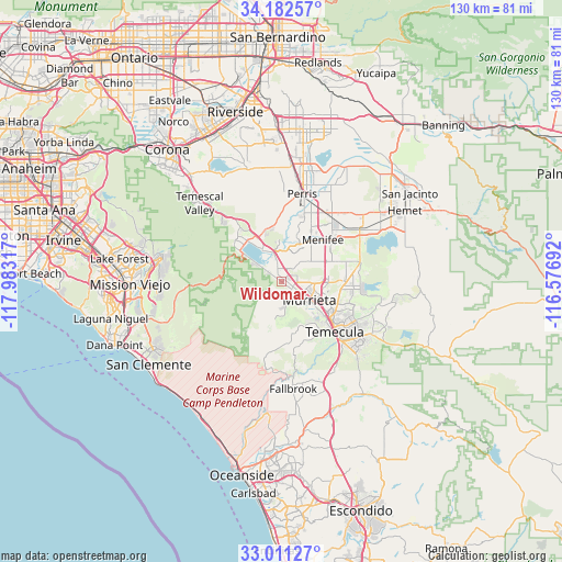
Wildomar GPS coordinates[2]
33° 35' 56.076" North, 117° 16' 48.144" West
| Map corner | latitude | longitude |
|---|---|---|
| Upper-left | 34.18257°, | -117.98317° |
| Center: | 33.59891°, | -117.28004° |
| Lower-right: | 33.01127°, | -116.57692° |
| Map W x H: | 130.2×130.2 km | = 80.9×80.9mi |
| max Lat: | 71.29058° ⇑82.7% North |
| Wildomar: | 33.59891° |
| min Lat: | ⇓17.3% South 19.06759° |
| min Long | Wildomar | max Long |
| -171.73463° | -117.28004° | -66.98998° |
| W 9.8%⇐ | ⇒90.2% E |
Elevation
Elevation of Wildomar is 385 m = 1263 ft, and this is 90.2 m = 296 ft above average elevation for this country.
| Max E: |
3189 m = 10463 ft | 17.3% |
| Wildomar | 385 m 1263 ft | |
| Avg. | 294.8 m = 967 ft | |
Min E: |
-60 m = -197 ft | 82.7% |
See also: United States elevation on elevation.city.
Geographical zone
Wildomar is located in North temperate zone (between Tropic of Cancer and the Arctic Circle). Distance of this Northern Tropic circle is 1129.9 km =702.1 mi to South.| Distance of | km | miles | from Wildomar |
|---|---|---|---|
| North Pole | 6271.2 | 3896.7 | to North |
| Arctic Circle | 3665.3 | 2277.5 | to North |
| Tropic Cancer | 1129.9 | 702.1 | to South |
| Equator | 3735.8 | 2321.3 | to South |


Nearby cities:
15 places around Wildomar: (largest is in red/bold)
• Canyon Lake
9.6 km =6 mi,  3°
3°
• Good Hope
18.5 km =11.5 mi, 3°
• Lake Elsinore
8.8 km =5.5 mi,  330°
330°
• Lakeland Village
7.4 km =4.6 mi,  306°
306°
• Meadowbrook
14.1 km =8.8 mi,  358°
358°
• Menifee
19 km =11.8 mi,  40°
40°
• Murrieta
7.9 km =4.9 mi,  129°
129°
• Murrieta Hot Springs
12.1 km =7.5 mi,  110°
110°
• Perris
21 km =13 mi,  13°
13°
• Quail Valley
12.4 km =7.7 mi,  15°
15°
• Romoland
19 km =11.8 mi,  30°
30°
• Sedco Hills
4.9 km =3 mi,  348°
348°
• Sun City
14.5 km =9 mi, 31°
• Temecula
16.9 km =10.5 mi, 133°
• Winchester
21.7 km =13.5 mi,  56°
56°
Sources, notices
• [Note1] Compared only with cities in United States existing in our database
• [Src1] Map data: © OpenStreetMap contributors (CC-BY-SA)
• [Src2] Other city data from geonames.org with taken over terms of usage.
• [Src3] Geographical zone / Annual Mean Temperature by Robert A. Rohde @ Wikipedia
