Temecula geodata
Temecula (California) is a populated place; located in United States in America/Los_Angeles (GMT-7) time zone. With population of 112,011 people, there are 293 cities with bigger population in this country. Compared to other cities in United States, 83.2% of cities are located further ↑North; 89.9% of cities are located further →East and 74.2% of cities have lower elevation than Temecula. Note1


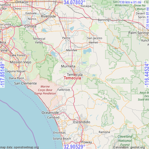
Temecula GPS coordinates[2]
33° 29' 37.104" North, 117° 8' 54.096" West
| Map corner | latitude | longitude |
|---|---|---|
| Upper-left | 34.07802°, | -117.85149° |
| Center: | 33.49364°, | -117.14836° |
| Lower-right: | 32.90529°, | -116.44524° |
| Map W x H: | 130.4×130.4 km | = 81×81mi |
| max Lat: | 71.29058° ⇑83.2% North |
| Temecula: | 33.49364° |
| min Lat: | ⇓16.8% South 19.06759° |
| min Long | Temecula | max Long |
| -171.73463° | -117.14836° | -66.98998° |
| W 10.1%⇐ | ⇒89.9% E |
Elevation
Elevation of Temecula is 308 m = 1010 ft, and this is 13.2 m = 43 ft above average elevation for this country.
| Max E: |
3189 m = 10463 ft | 25.8% |
| Temecula | 308 m 1010 ft | |
| Avg. | 294.8 m = 967 ft | |
Min E: |
-60 m = -197 ft | 74.2% |
See also: Temecula elevation on elevation.city.
Geographical zone
Temecula is located in North temperate zone (between Tropic of Cancer and the Arctic Circle). Distance of this Northern Tropic circle is 1118.2 km =694.8 mi to South.| Distance of | km | miles | from Temecula |
|---|---|---|---|
| North Pole | 6282.9 | 3904 | to North |
| Arctic Circle | 3677 | 2284.8 | to North |
| Tropic Cancer | 1118.2 | 694.8 | to South |
| Equator | 3724.1 | 2314 | to South |


Nearby cities:
15 places around Temecula: (largest is in red/bold)
• Bonsall
23.9 km =14.9 mi,  197°
197°
• Camp Pendleton North
25.3 km =15.7 mi,  218°
218°
• Canyon Lake
24.2 km =15 mi,  331°
331°
• Fallbrook
16.2 km =10.1 mi, 216°
• Lake Elsinore
25.5 km =15.8 mi,  319°
319°
• Lakeland Village
24.3 km =15.1 mi,  311°
311°
• Menifee
26.1 km =16.2 mi,  0°
0°
• Murrieta
9 km =5.6 mi, 317°
• Murrieta Hot Springs
7.5 km =4.7 mi,  353°
353°
• Quail Valley
25.4 km =15.8 mi,  339°
339°
• Rainbow
9.3 km =5.8 mi,  179°
179°
• Sedco Hills
21.1 km =13.1 mi, 321°
• Sun City
24.4 km =15.2 mi, 349°
• Wildomar
16.9 km =10.5 mi, 313°
• Winchester
24.4 km =15.2 mi,  14°
14°
Sources, notices
• [Note1] Compared only with cities in United States existing in our database
• [Src1] Map data: © OpenStreetMap contributors (CC-BY-SA)
• [Src2] Other city data from geonames.org with taken over terms of usage.
• [Src3] Geographical zone / Annual Mean Temperature by Robert A. Rohde @ Wikipedia
