Woodland geodata
Woodland (California) is a seat of a second-order administrative division; located in United States in America/Los_Angeles (GMT-7) time zone. With population of 58,567 people, there are 776 cities with bigger population in this country. Compared to other cities in United States, 57.6% of cities are located further ↑North; 94.7% of cities are located further →East and 87.8% of cities have higher elevation than Woodland. Note1


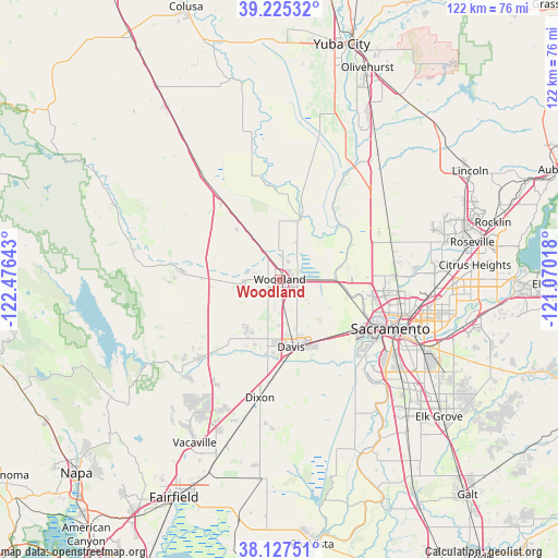
Woodland GPS coordinates[2]
38° 40' 42.672" North, 121° 46' 23.88" West
| Map corner | latitude | longitude |
|---|---|---|
| Upper-left | 39.22532°, | -122.47643° |
| Center: | 38.67852°, | -121.7733° |
| Lower-right: | 38.12751°, | -121.07018° |
| Map W x H: | 122.1×122.1 km | = 75.9×75.9mi |
| max Lat: | 71.29058° ⇑57.6% North |
| Woodland: | 38.67852° |
| min Lat: | ⇓42.4% South 19.06759° |
| min Long | Woodland | max Long |
| -171.73463° | -121.7733° | -66.98998° |
| W 5.3%⇐ | ⇒94.7% E |
Elevation
Elevation of Woodland is 21 m = 69 ft, and this is 273.8 m = 898 ft below average elevation for this country.
| Max E: |
3189 m = 10463 ft | 87.8% |
| Avg. | 294.8 m = 967 ft | |
| Woodland | 21 m = 69 ft | |
Min E: |
-60 m = -197 ft | 12.2% |
See also: Woodland elevation on elevation.city.
Geographical zone
Woodland is located in North temperate zone (between Tropic of Cancer and the Arctic Circle). Distance of this Northern Tropic circle is 1694.7 km =1053 mi to South.| Distance of | km | miles | from Woodland |
|---|---|---|---|
| North Pole | 5706.4 | 3545.8 | to North |
| Arctic Circle | 3100.5 | 1926.6 | to North |
| Tropic Cancer | 1694.7 | 1053 | to South |
| Equator | 4300.6 | 2672.3 | to South |


Nearby cities:
15 places around Woodland: (largest is in red/bold)
• Allendale
29.9 km =18.6 mi,  209°
209°
• Cottonwood
17.3 km =10.7 mi,  262°
262°
• Davis
15.1 km =9.4 mi,  169°
169°
• Dixon
26.3 km =16.3 mi,  189°
189°
• Dunnigan
28.6 km =17.8 mi,  323°
323°
• Elverta
27.2 km =16.9 mi,  81°
81°
• Esparto
21.2 km =13.2 mi,  274°
274°
• Fruitridge Pocket
32 km =19.9 mi,  120°
120°
• Knights Landing
14.3 km =8.9 mi,  19°
19°
• Madison
16.9 km =10.5 mi, 270°
• Monument Hills
9 km =5.6 mi, 259°
• Rio Linda
28.2 km =17.5 mi,  87°
87°
• Sacramento
26.5 km =16.5 mi,  113°
113°
• West Sacramento
23.8 km =14.8 mi, 117°
• Winters
24.2 km =15 mi,  225°
225°
Sources, notices
• [Note1] Compared only with cities in United States existing in our database
• [Src1] Map data: © OpenStreetMap contributors (CC-BY-SA)
• [Src2] Other city data from geonames.org with taken over terms of usage.
• [Src3] Geographical zone / Annual Mean Temperature by Robert A. Rohde @ Wikipedia
