Madison geodata
Madison (California) is a populated place; located in United States in America/Los_Angeles (GMT-7) time zone. With population of 503 people, there are 20865 cities with bigger population in this country. Compared to other cities in United States, 57.6% of cities are located further ↑North; 95% of cities are located further →East and 80.6% of cities have higher elevation than Madison. Note1


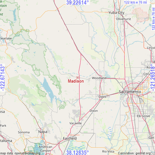
Madison GPS coordinates[2]
38° 40' 45.66" North, 121° 58' 5.88" West
| Map corner | latitude | longitude |
|---|---|---|
| Upper-left | 39.22614°, | -122.67143° |
| Center: | 38.67935°, | -121.9683° |
| Lower-right: | 38.12835°, | -121.26518° |
| Map W x H: | 122.1×122.1 km | = 75.9×75.9mi |
| max Lat: | 71.29058° ⇑57.6% North |
| Madison: | 38.67935° |
| min Lat: | ⇓42.4% South 19.06759° |
| min Long | Madison | max Long |
| -171.73463° | -121.9683° | -66.98998° |
| W 5%⇐ | ⇒95% E |
Elevation
Elevation of Madison is 44 m = 144 ft, and this is 250.8 m = 823 ft below average elevation for this country.
| Max E: |
3189 m = 10463 ft | 80.6% |
| Avg. | 294.8 m = 967 ft | |
| Madison | 44 m = 144 ft | |
Min E: |
-60 m = -197 ft | 19.4% |
See also: United States elevation on elevation.city.
Geographical zone
Madison is located in North temperate zone (between Tropic of Cancer and the Arctic Circle). Distance of this Northern Tropic circle is 1694.8 km =1053.1 mi to South.| Distance of | km | miles | from Madison |
|---|---|---|---|
| North Pole | 5706.3 | 3545.7 | to North |
| Arctic Circle | 3100.4 | 1926.5 | to North |
| Tropic Cancer | 1694.8 | 1053.1 | to South |
| Equator | 4300.7 | 2672.3 | to South |


Nearby cities:
15 places around Madison: (largest is in red/bold)
• Allendale
26.2 km =16.3 mi,  175°
175°
• Arbuckle
38.4 km =23.9 mi,  348°
348°
• Cottonwood
2.4 km =1.5 mi,  185°
185°
• Davis
24.8 km =15.4 mi,  127°
127°
• Dixon
28.9 km =18 mi,  154°
154°
• Dunnigan
22.9 km =14.2 mi,  359°
359°
• Esparto
4.5 km =2.8 mi,  288°
288°
• Hartley
29.2 km =18.1 mi, 176°
• Knights Landing
25.5 km =15.8 mi,  58°
58°
• Monument Hills
8.2 km =5.1 mi,  101°
101°
• Sacramento
42.6 km =26.5 mi, 104°
• Vacaville
35.9 km =22.3 mi, 182°
• West Sacramento
39.6 km =24.6 mi,  106°
106°
• Winters
17.2 km =10.7 mi, 180°
• Woodland
16.9 km =10.5 mi,  90°
90°
Sources, notices
• [Note1] Compared only with cities in United States existing in our database
• [Src1] Map data: © OpenStreetMap contributors (CC-BY-SA)
• [Src2] Other city data from geonames.org with taken over terms of usage.
• [Src3] Geographical zone / Annual Mean Temperature by Robert A. Rohde @ Wikipedia
