Aurora geodata
Aurora (Colorado) is a populated place; located in United States in America/Denver (GMT-6) time zone. With population of 359,407 people, there are 60 cities with bigger population in this country. Compared to other cities in United States, 50.9% of cities are located further ↓South; 83.1% of cities are located further →East and 97.7% of cities have lower elevation than Aurora. Note1


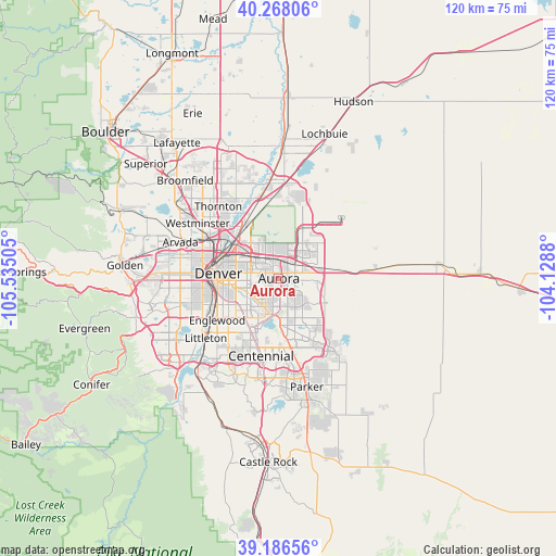
Aurora GPS coordinates[2]
39° 43' 45.948" North, 104° 49' 54.912" West
| Map corner | latitude | longitude |
|---|---|---|
| Upper-left | 40.26806°, | -105.53505° |
| Center: | 39.72943°, | -104.83192° |
| Lower-right: | 39.18656°, | -104.1288° |
| Map W x H: | 120.3×120.3 km | = 74.8×74.8mi |
| max Lat: | 71.29058° ⇑49.1% North |
| Aurora: | 39.72943° |
| min Lat: | ⇓50.9% South 19.06759° |
| min Long | Aurora | max Long |
| -171.73463° | -104.83192° | -66.98998° |
| W 16.9%⇐ | ⇒83.1% E |
Elevation
Elevation of Aurora is 1651 m = 5417 ft, and this is 1356.2 m = 4449 ft above average elevation for this country.
| Max E: |
3189 m = 10463 ft | 2.3% |
| Aurora | 1651 m 5417 ft | |
| Avg. | 294.8 m = 967 ft | |
Min E: |
-60 m = -197 ft | 97.7% |
See also: Aurora elevation on elevation.city.
Geographical zone
Aurora is located in North temperate zone (between Tropic of Cancer and the Arctic Circle). Distance of this Northern Tropic circle is 1811.6 km =1125.7 mi to South.| Distance of | km | miles | from Aurora |
|---|---|---|---|
| North Pole | 5589.6 | 3473.2 | to North |
| Arctic Circle | 2983.7 | 1854 | to North |
| Tropic Cancer | 1811.6 | 1125.7 | to South |
| Equator | 4417.5 | 2744.9 | to South |


Nearby cities:
15 places around Aurora: (largest is in red/bold)
• Aetna Estates
13.6 km =8.5 mi,  85°
85°
• Centennial
17.1 km =10.6 mi,  192°
192°
• Cherry Creek
11.4 km =7.1 mi,  202°
202°
• Cherry Hills Village
14.6 km =9.1 mi,  228°
228°
• Commerce City
12.4 km =7.7 mi,  315°
315°
• Denver
13.1 km =8.1 mi,  274°
274°
• Derby
14.3 km =8.9 mi,  328°
328°
• Dove Valley
16.9 km =10.5 mi,  179°
179°
• Englewood
16.1 km =10 mi,  235°
235°
• Foxfield
15.7 km =9.8 mi,  167°
167°
• Glendale
9.1 km =5.7 mi,  252°
252°
• Greenwood Village
16.1 km =10 mi,  219°
219°
• Holly Hills
10.1 km =6.3 mi, 226°
• Inverness
17.1 km =10.6 mi, 188°
• Welby
16.1 km =10 mi, 317°
Sources, notices
• [Note1] Compared only with cities in United States existing in our database
• [Src1] Map data: © OpenStreetMap contributors (CC-BY-SA)
• [Src2] Other city data from geonames.org with taken over terms of usage.
• [Src3] Geographical zone / Annual Mean Temperature by Robert A. Rohde @ Wikipedia
