Denver geodata
Denver (Colorado) is a seat of a first-order administrative division; located in United States in America/Denver (GMT-6) time zone. With population of 682,545 people, there are 22 cities with bigger population in this country. Compared to other cities in United States, 51% of cities are located further ↓South; 83.3% of cities are located further →East and 97.6% of cities have lower elevation than Denver. Note1


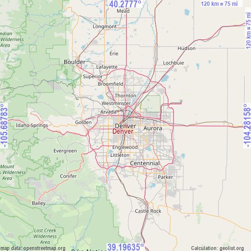
Denver GPS coordinates[2]
39° 44' 20.94" North, 104° 59' 4.92" West
| Map corner | latitude | longitude |
|---|---|---|
| Upper-left | 40.2777°, | -105.68783° |
| Center: | 39.73915°, | -104.9847° |
| Lower-right: | 39.19635°, | -104.28158° |
| Map W x H: | 120.2×120.2 km | = 74.7×74.7mi |
| max Lat: | 71.29058° ⇑49% North |
| Denver: | 39.73915° |
| min Lat: | ⇓51% South 19.06759° |
| min Long | Denver | max Long |
| -171.73463° | -104.9847° | -66.98998° |
| W 16.7%⇐ | ⇒83.3% E |
Elevation
Elevation of Denver is 1636 m = 5367 ft, and this is 1341.2 m = 4400 ft above average elevation for this country.
| Max E: |
3189 m = 10463 ft | 2.4% |
| Denver | 1636 m 5367 ft | |
| Avg. | 294.8 m = 967 ft | |
Min E: |
-60 m = -197 ft | 97.6% |
See also: Denver elevation on elevation.city.
Geographical zone
Denver is located in North temperate zone (between Tropic of Cancer and the Arctic Circle). Distance of this Northern Tropic circle is 1812.7 km =1126.4 mi to South.| Distance of | km | miles | from Denver |
|---|---|---|---|
| North Pole | 5588.5 | 3472.5 | to North |
| Arctic Circle | 2982.6 | 1853.3 | to North |
| Tropic Cancer | 1812.7 | 1126.4 | to South |
| Equator | 4418.6 | 2745.6 | to South |


Nearby cities:
15 places around Denver: (largest is in red/bold)
• Arvada
11.3 km =7 mi,  308°
308°
• Berkley
8.1 km =5 mi,  334°
334°
• Cherry Hills Village
11.1 km =6.9 mi,  168°
168°
• Commerce City
8.8 km =5.5 mi,  29°
29°
• Edgewater
7 km =4.3 mi,  282°
282°
• Englewood
10.2 km =6.3 mi,  181°
181°
• Glendale
5.8 km =3.6 mi,  130°
130°
• Holly Hills
9.8 km =6.1 mi,  144°
144°
• Lakewood
9.1 km =5.7 mi,  245°
245°
• Mountain View
7.2 km =4.5 mi,  302°
302°
• Sheridan
10.8 km =6.7 mi,  198°
198°
• Sherrelwood
11.1 km =6.9 mi,  352°
352°
• Twin Lakes
9.7 km =6 mi, 349°
• Welby
11.1 km =6.9 mi,  11°
11°
• Wheat Ridge
8.5 km =5.3 mi,  290°
290°
Sources, notices
• [Note1] Compared only with cities in United States existing in our database
• [Src1] Map data: © OpenStreetMap contributors (CC-BY-SA)
• [Src2] Other city data from geonames.org with taken over terms of usage.
• [Src3] Geographical zone / Annual Mean Temperature by Robert A. Rohde @ Wikipedia
