Englewood geodata
Englewood (Colorado) is a populated place; located in United States in America/Denver (GMT-6) time zone. With population of 33,082 people, there are 1501 cities with bigger population in this country. Compared to other cities in United States, 50.3% of cities are located further ↓South; 83.3% of cities are located further →East and 97.6% of cities have lower elevation than Englewood. Note1


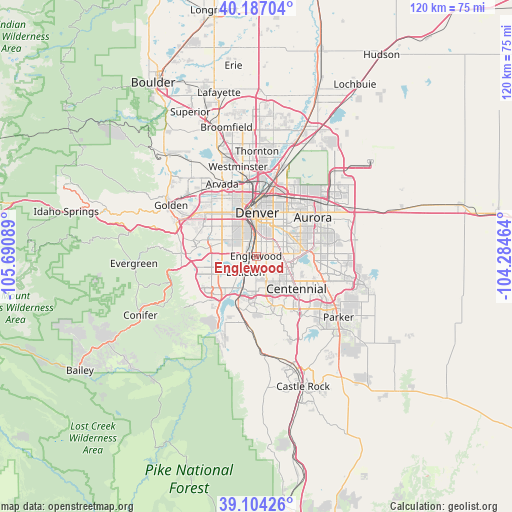
Englewood GPS coordinates[2]
39° 38' 51.972" North, 104° 59' 15.936" West
| Map corner | latitude | longitude |
|---|---|---|
| Upper-left | 40.18704°, | -105.69089° |
| Center: | 39.64777°, | -104.98776° |
| Lower-right: | 39.10426°, | -104.28464° |
| Map W x H: | 120.4×120.4 km | = 74.8×74.8mi |
| max Lat: | 71.29058° ⇑49.7% North |
| Englewood: | 39.64777° |
| min Lat: | ⇓50.3% South 19.06759° |
| min Long | Englewood | max Long |
| -171.73463° | -104.98776° | -66.98998° |
| W 16.7%⇐ | ⇒83.3% E |
Elevation
Elevation of Englewood is 1642 m = 5387 ft, and this is 1347.2 m = 4420 ft above average elevation for this country.
| Max E: |
3189 m = 10463 ft | 2.4% |
| Englewood | 1642 m 5387 ft | |
| Avg. | 294.8 m = 967 ft | |
Min E: |
-60 m = -197 ft | 97.6% |
See also: United States elevation on elevation.city.
Geographical zone
Englewood is located in North temperate zone (between Tropic of Cancer and the Arctic Circle). Distance of this Northern Tropic circle is 1802.5 km =1120 mi to South.| Distance of | km | miles | from Englewood |
|---|---|---|---|
| North Pole | 5598.6 | 3478.8 | to North |
| Arctic Circle | 2992.8 | 1859.6 | to North |
| Tropic Cancer | 1802.5 | 1120 | to South |
| Equator | 4408.4 | 2739.3 | to South |


Nearby cities:
15 places around Englewood: (largest is in red/bold)
• Bow Mar
5.7 km =3.5 mi,  247°
247°
• Castlewood
10.2 km =6.3 mi,  133°
133°
• Cherry Creek
9.1 km =5.7 mi,  99°
99°
• Cherry Hills Village
2.5 km =1.6 mi,  105°
105°
• Columbine
9.7 km =6 mi,  226°
226°
• Columbine Valley
6.4 km =4 mi,  216°
216°
• Denver
10.2 km =6.3 mi,  1°
1°
• Glendale
7.9 km =4.9 mi,  36°
36°
• Greenwood Village
4.6 km =2.9 mi,  137°
137°
• Highlands Ranch
10.6 km =6.6 mi,  171°
171°
• Holly Hills
6.4 km =4 mi,  69°
69°
• Lakewood
10.2 km =6.3 mi,  308°
308°
• Littleton
4.6 km =2.9 mi,  212°
212°
• Sheridan
3.2 km =2 mi,  268°
268°
• Southglenn
7.4 km =4.6 mi,  156°
156°
Sources, notices
• [Note1] Compared only with cities in United States existing in our database
• [Src1] Map data: © OpenStreetMap contributors (CC-BY-SA)
• [Src2] Other city data from geonames.org with taken over terms of usage.
• [Src3] Geographical zone / Annual Mean Temperature by Robert A. Rohde @ Wikipedia
