Dolores geodata
Dolores (Colorado) is a populated place; located in United States in America/Denver (GMT-6) time zone. With population of 963 people, there are 16543 cities with bigger population in this country. Compared to other cities in United States, 64.2% of cities are located further ↑North; 85.2% of cities are located further →East and 99.5% of cities have lower elevation than Dolores. Note1


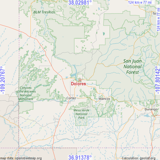
Dolores GPS coordinates[2]
37° 28' 25.968" North, 108° 30' 16.344" West
| Map corner | latitude | longitude |
|---|---|---|
| Upper-left | 38.02981°, | -109.20767° |
| Center: | 37.47388°, | -108.50454° |
| Lower-right: | 36.91378°, | -107.80142° |
| Map W x H: | 124.1×124.1 km | = 77.1×77.1mi |
| max Lat: | 71.29058° ⇑64.2% North |
| Dolores: | 37.47388° |
| min Lat: | ⇓35.8% South 19.06759° |
| min Long | Dolores | max Long |
| -171.73463° | -108.50454° | -66.98998° |
| W 14.8%⇐ | ⇒85.2% E |
Elevation
Elevation of Dolores is 2120 m = 6955 ft, and this is 1825.2 m = 5988 ft above average elevation for this country.
| Max E: |
3189 m = 10463 ft | 0.5% |
| Dolores | 2120 m 6955 ft | |
| Avg. | 294.8 m = 967 ft | |
Min E: |
-60 m = -197 ft | 99.5% |
See also: United States elevation on elevation.city.
Geographical zone
Dolores is located in North temperate zone (between Tropic of Cancer and the Arctic Circle). Distance of this Northern Tropic circle is 1560.8 km =969.8 mi to South.| Distance of | km | miles | from Dolores |
|---|---|---|---|
| North Pole | 5840.4 | 3629.1 | to North |
| Arctic Circle | 3234.5 | 2009.8 | to North |
| Tropic Cancer | 1560.8 | 969.8 | to South |
| Equator | 4166.7 | 2589.1 | to South |


Nearby cities:
15 places around Dolores: (largest is in red/bold)
• Aneth
66.8 km =41.5 mi,  244°
244°
• Cedar Hill
80.8 km =50.2 mi,  137°
137°
• Cortez
15.6 km =9.7 mi,  207°
207°
• Dove Creek
48 km =29.8 mi,  312°
312°
• Durango
59.4 km =36.9 mi,  111°
111°
• La Plata
66.7 km =41.4 mi,  155°
155°
• Mancos
23.8 km =14.8 mi,  127°
127°
• Mountain Village
76.4 km =47.5 mi,  48°
48°
• Nenahnezad
82.4 km =51.2 mi,  174°
174°
• Norwood
75.4 km =46.9 mi,  14°
14°
• Shiprock
78.2 km =48.6 mi,  191°
191°
• Teec Nos Pos
80.2 km =49.8 mi,  219°
219°
• Telluride
79.8 km =49.6 mi, 49°
• Towaoc
36 km =22.4 mi, 213°
• Waterflow
79.4 km =49.3 mi,  178°
178°
Sources, notices
• [Note1] Compared only with cities in United States existing in our database
• [Src1] Map data: © OpenStreetMap contributors (CC-BY-SA)
• [Src2] Other city data from geonames.org with taken over terms of usage.
• [Src3] Geographical zone / Annual Mean Temperature by Robert A. Rohde @ Wikipedia
