Cortez geodata
Cortez (Colorado) is a seat of a second-order administrative division; located in United States in America/Denver (GMT-6) time zone. With population of 8,715 people, there are 4920 cities with bigger population in this country. Compared to other cities in United States, 64.6% of cities are located further ↑North; 85.3% of cities are located further →East and 98.8% of cities have lower elevation than Cortez. Note1


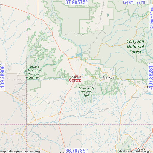
Cortez GPS coordinates[2]
37° 20' 55.968" North, 108° 35' 9.348" West
| Map corner | latitude | longitude |
|---|---|---|
| Upper-left | 37.90575°, | -109.28906° |
| Center: | 37.34888°, | -108.58593° |
| Lower-right: | 36.78785°, | -107.88281° |
| Map W x H: | 124.3×124.3 km | = 77.2×77.2mi |
| max Lat: | 71.29058° ⇑64.6% North |
| Cortez: | 37.34888° |
| min Lat: | ⇓35.4% South 19.06759° |
| min Long | Cortez | max Long |
| -171.73463° | -108.58593° | -66.98998° |
| W 14.7%⇐ | ⇒85.3% E |
Elevation
Elevation of Cortez is 1895 m = 6217 ft, and this is 1600.2 m = 5250 ft above average elevation for this country.
| Max E: |
3189 m = 10463 ft | 1.2% |
| Cortez | 1895 m 6217 ft | |
| Avg. | 294.8 m = 967 ft | |
Min E: |
-60 m = -197 ft | 98.8% |
See also: United States elevation on elevation.city.
Geographical zone
Cortez is located in North temperate zone (between Tropic of Cancer and the Arctic Circle). Distance of this Northern Tropic circle is 1546.9 km =961.2 mi to South.| Distance of | km | miles | from Cortez |
|---|---|---|---|
| North Pole | 5854.3 | 3637.7 | to North |
| Arctic Circle | 3248.4 | 2018.5 | to North |
| Tropic Cancer | 1546.9 | 961.2 | to South |
| Equator | 4152.8 | 2580.4 | to South |


Nearby cities:
15 places around Cortez: (largest is in red/bold)
• Aneth
55.2 km =34.3 mi,  254°
254°
• Dolores
15.6 km =9.7 mi,  27°
27°
• Dove Creek
54.3 km =33.7 mi,  328°
328°
• Durango
63 km =39.1 mi,  97°
97°
• Kirtland
71.2 km =44.2 mi,  163°
163°
• La Plata
58.4 km =36.3 mi,  143°
143°
• Mancos
26.2 km =16.3 mi,  90°
90°
• Nenahnezad
69.7 km =43.3 mi,  167°
167°
• Ojo Amarillo
75.4 km =46.9 mi, 165°
• Shiprock
63.3 km =39.3 mi,  188°
188°
• Spencerville
75.2 km =46.7 mi, 141°
• Teec Nos Pos
65 km =40.4 mi,  222°
222°
• Towaoc
20.5 km =12.7 mi, 218°
• Upper Fruitland
74.4 km =46.2 mi, 161°
• Waterflow
66.2 km =41.1 mi, 171°
Sources, notices
• [Note1] Compared only with cities in United States existing in our database
• [Src1] Map data: © OpenStreetMap contributors (CC-BY-SA)
• [Src2] Other city data from geonames.org with taken over terms of usage.
• [Src3] Geographical zone / Annual Mean Temperature by Robert A. Rohde @ Wikipedia
