Mancos geodata
Mancos (Colorado) is a populated place; located in United States in America/Denver (GMT-6) time zone. With population of 1,380 people, there are 14208 cities with bigger population in this country. Compared to other cities in United States, 64.7% of cities are located further ↑North; 85.1% of cities are located further →East and 99.5% of cities have lower elevation than Mancos. Note1


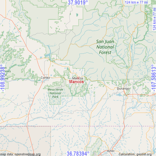
Mancos GPS coordinates[2]
37° 20' 42" North, 108° 17' 21.3" West
| Map corner | latitude | longitude |
|---|---|---|
| Upper-left | 37.9019°, | -108.99238° |
| Center: | 37.345°, | -108.28925° |
| Lower-right: | 36.78394°, | -107.58613° |
| Map W x H: | 124.3×124.3 km | = 77.2×77.2mi |
| max Lat: | 71.29058° ⇑64.7% North |
| Mancos: | 37.345° |
| min Lat: | ⇓35.3% South 19.06759° |
| min Long | Mancos | max Long |
| -171.73463° | -108.28925° | -66.98998° |
| W 14.9%⇐ | ⇒85.1% E |
Elevation
Elevation of Mancos is 2144 m = 7034 ft, and this is 1849.2 m = 6067 ft above average elevation for this country.
| Max E: |
3189 m = 10463 ft | 0.5% |
| Mancos | 2144 m 7034 ft | |
| Avg. | 294.8 m = 967 ft | |
Min E: |
-60 m = -197 ft | 99.5% |
See also: United States elevation on elevation.city.
Geographical zone
Mancos is located in North temperate zone (between Tropic of Cancer and the Arctic Circle). Distance of this Northern Tropic circle is 1546.5 km =961 mi to South.| Distance of | km | miles | from Mancos |
|---|---|---|---|
| North Pole | 5854.7 | 3637.9 | to North |
| Arctic Circle | 3248.8 | 2018.7 | to North |
| Tropic Cancer | 1546.5 | 961 | to South |
| Equator | 4152.4 | 2580.2 | to South |


Nearby cities:
15 places around Mancos: (largest is in red/bold)
• Aztec
63.8 km =39.6 mi,  155°
155°
• Bayfield
62.6 km =38.9 mi,  102°
102°
• Cedar Hill
57.5 km =35.7 mi,  142°
142°
• Cortez
26.2 km =16.3 mi,  270°
270°
• Dolores
23.8 km =14.8 mi,  307°
307°
• Durango
37 km =23 mi, 102°
• Farmington
68.9 km =42.8 mi,  174°
174°
• Flora Vista
64 km =39.8 mi, 163°
• Ignacio
63.5 km =39.5 mi,  113°
113°
• Kirtland
68.2 km =42.4 mi,  185°
185°
• La Plata
47.1 km =29.3 mi, 169°
• Nenahnezad
68.7 km =42.7 mi, 189°
• Spencerville
61.9 km =38.5 mi, 160°
• Towaoc
42 km =26.1 mi,  248°
248°
• Waterflow
67.3 km =41.8 mi, 194°
Sources, notices
• [Note1] Compared only with cities in United States existing in our database
• [Src1] Map data: © OpenStreetMap contributors (CC-BY-SA)
• [Src2] Other city data from geonames.org with taken over terms of usage.
• [Src3] Geographical zone / Annual Mean Temperature by Robert A. Rohde @ Wikipedia
