Colby geodata
Colby (Kansas) is a seat of a second-order administrative division; located in United States in America/Chicago (GMT-5) time zone. With population of 5,417 people, there are 6825 cities with bigger population in this country. Compared to other cities in United States, 51.6% of cities are located further ↑North; 81.4% of cities are located further →East and 93.2% of cities have lower elevation than Colby. Note1


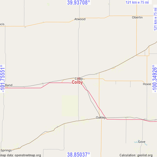
Colby GPS coordinates[2]
39° 23' 45.024" North, 101° 3' 8.568" West
| Map corner | latitude | longitude |
|---|---|---|
| Upper-left | 39.93708°, | -101.75551° |
| Center: | 39.39584°, | -101.05238° |
| Lower-right: | 38.85037°, | -100.34926° |
| Map W x H: | 120.8×120.8 km | = 75.1×75.1mi |
| max Lat: | 71.29058° ⇑51.6% North |
| Colby: | 39.39584° |
| min Lat: | ⇓48.4% South 19.06759° |
| min Long | Colby | max Long |
| -171.73463° | -101.05238° | -66.98998° |
| W 18.6%⇐ | ⇒81.4% E |
Elevation
Elevation of Colby is 967 m = 3173 ft, and this is 672.2 m = 2205 ft above average elevation for this country.
| Max E: |
3189 m = 10463 ft | 6.8% |
| Colby | 967 m 3173 ft | |
| Avg. | 294.8 m = 967 ft | |
Min E: |
-60 m = -197 ft | 93.2% |
See also: United States elevation on elevation.city.
Geographical zone
Colby is located in North temperate zone (between Tropic of Cancer and the Arctic Circle). Distance of this Northern Tropic circle is 1774.5 km =1102.6 mi to South.| Distance of | km | miles | from Colby |
|---|---|---|---|
| North Pole | 5626.7 | 3496.3 | to North |
| Arctic Circle | 3020.8 | 1877 | to North |
| Tropic Cancer | 1774.5 | 1102.6 | to South |
| Equator | 4380.4 | 2721.9 | to South |


Nearby cities:
15 places around Colby: (largest is in red/bold)
• Atwood
45.7 km =28.4 mi,  1°
1°
• Benkelman
83.5 km =51.9 mi,  330°
330°
• Culbertson
94.5 km =58.7 mi,  11°
11°
• Goodland
56.8 km =35.3 mi,  264°
264°
• Gove
68.8 km =42.8 mi,  135°
135°
• Hill City
104.1 km =64.7 mi,  91°
91°
• Hoxie
52.7 km =32.7 mi, 94°
• McCook
96.8 km =60.1 mi,  22°
22°
• Oakley
33.4 km =20.8 mi,  150°
150°
• Oberlin
65 km =40.4 mi,  43°
43°
• Quinter
79.4 km =49.3 mi,  117°
117°
• Saint Francis
76.5 km =47.5 mi,  303°
303°
• Scott City
102.3 km =63.6 mi,  172°
172°
• Sharon Springs
81.9 km =50.9 mi,  227°
227°
• Trenton
86.8 km =53.9 mi, 2°
Sources, notices
• [Note1] Compared only with cities in United States existing in our database
• [Src1] Map data: © OpenStreetMap contributors (CC-BY-SA)
• [Src2] Other city data from geonames.org with taken over terms of usage.
• [Src3] Geographical zone / Annual Mean Temperature by Robert A. Rohde @ Wikipedia
