Scott City geodata
Scott City (Kansas) is a seat of a second-order administrative division; located in United States in America/Chicago (GMT-5) time zone. With population of 3,838 people, there are 8411 cities with bigger population in this country. Compared to other cities in United States, 58.9% of cities are located further ↑North; 81.3% of cities are located further →East and 92.9% of cities have lower elevation than Scott City. Note1


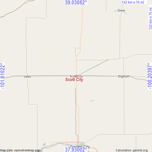
Scott City GPS coordinates[2]
38° 28' 57.072" North, 100° 54' 25.524" West
| Map corner | latitude | longitude |
|---|---|---|
| Upper-left | 39.03082°, | -101.61022° |
| Center: | 38.48252°, | -100.90709° |
| Lower-right: | 37.93002°, | -100.20397° |
| Map W x H: | 122.4×122.4 km | = 76.1×76.1mi |
| max Lat: | 71.29058° ⇑58.9% North |
| Scott City: | 38.48252° |
| min Lat: | ⇓41.1% South 19.06759° |
| min Long | Scott City | max Long |
| -171.73463° | -100.90709° | -66.98998° |
| W 18.7%⇐ | ⇒81.3% E |
Elevation
Elevation of Scott City is 913 m = 2995 ft, and this is 618.2 m = 2028 ft above average elevation for this country.
| Max E: |
3189 m = 10463 ft | 7.1% |
| Scott City | 913 m 2995 ft | |
| Avg. | 294.8 m = 967 ft | |
Min E: |
-60 m = -197 ft | 92.9% |
See also: United States elevation on elevation.city.
Geographical zone
Scott City is located in North temperate zone (between Tropic of Cancer and the Arctic Circle). Distance of this Northern Tropic circle is 1672.9 km =1039.5 mi to South.| Distance of | km | miles | from Scott City |
|---|---|---|---|
| North Pole | 5728.2 | 3559.3 | to North |
| Arctic Circle | 3122.3 | 1940.1 | to North |
| Tropic Cancer | 1672.9 | 1039.5 | to South |
| Equator | 4278.9 | 2658.8 | to South |


Nearby cities:
15 places around Scott City: (largest is in red/bold)
• Cimarron
89.6 km =55.7 mi,  146°
146°
• Deerfield
59.3 km =36.8 mi,  199°
199°
• Dighton
38.3 km =23.8 mi,  90°
90°
• Garden City
56.9 km =35.4 mi,  176°
176°
• Gove
64.1 km =39.8 mi,  34°
34°
• Holcomb
55.7 km =34.6 mi,  187°
187°
• Jetmore
98.9 km =61.5 mi,  116°
116°
• Lakin
67.5 km =41.9 mi,  206°
206°
• Leoti
39.3 km =24.4 mi,  269°
269°
• Ness City
87.2 km =54.2 mi, 92°
• Oakley
72.5 km =45 mi,  2°
2°
• Quinter
87.6 km =54.4 mi,  41°
41°
• Sharon Springs
86.7 km =53.9 mi,  302°
302°
• Syracuse
92.7 km =57.6 mi,  232°
232°
• Tribune
73.6 km =45.7 mi, 268°
Sources, notices
• [Note1] Compared only with cities in United States existing in our database
• [Src1] Map data: © OpenStreetMap contributors (CC-BY-SA)
• [Src2] Other city data from geonames.org with taken over terms of usage.
• [Src3] Geographical zone / Annual Mean Temperature by Robert A. Rohde @ Wikipedia
