Quinter geodata
Quinter (Kansas) is a populated place; located in United States in America/Chicago (GMT-5) time zone. With population of 948 people, there are 16654 cities with bigger population in this country. Compared to other cities in United States, 54.2% of cities are located further ↑North; 80.9% of cities are located further →East and 92.2% of cities have lower elevation than Quinter. Note1


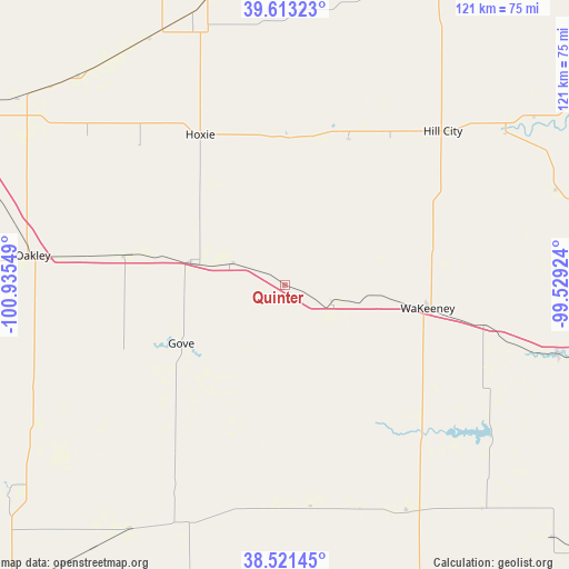
Quinter GPS coordinates[2]
39° 4' 10.02" North, 100° 13' 56.496" West
| Map corner | latitude | longitude |
|---|---|---|
| Upper-left | 39.61323°, | -100.93549° |
| Center: | 39.06945°, | -100.23236° |
| Lower-right: | 38.52145°, | -99.52924° |
| Map W x H: | 121.4×121.4 km | = 75.4×75.4mi |
| max Lat: | 71.29058° ⇑54.2% North |
| Quinter: | 39.06945° |
| min Lat: | ⇓45.8% South 19.06759° |
| min Long | Quinter | max Long |
| -171.73463° | -100.23236° | -66.98998° |
| W 19.1%⇐ | ⇒80.9% E |
Elevation
Elevation of Quinter is 823 m = 2700 ft, and this is 528.2 m = 1733 ft above average elevation for this country.
| Max E: |
3189 m = 10463 ft | 7.8% |
| Quinter | 823 m 2700 ft | |
| Avg. | 294.8 m = 967 ft | |
Min E: |
-60 m = -197 ft | 92.2% |
See also: United States elevation on elevation.city.
Geographical zone
Quinter is located in North temperate zone (between Tropic of Cancer and the Arctic Circle). Distance of this Northern Tropic circle is 1738.2 km =1080.1 mi to South.| Distance of | km | miles | from Quinter |
|---|---|---|---|
| North Pole | 5662.9 | 3518.8 | to North |
| Arctic Circle | 3057.1 | 1899.6 | to North |
| Tropic Cancer | 1738.2 | 1080.1 | to South |
| Equator | 4344.1 | 2699.3 | to South |


Nearby cities:
15 places around Quinter: (largest is in red/bold)
• Colby
79.4 km =49.3 mi,  297°
297°
• Dighton
68.4 km =42.5 mi,  197°
197°
• Ellis
59.8 km =37.2 mi,  104°
104°
• Gove
25.4 km =15.8 mi,  240°
240°
• Hays
81.1 km =50.4 mi,  105°
105°
• Hill City
47 km =29.2 mi,  45°
45°
• Hoxie
36.8 km =22.9 mi,  330°
330°
• Logan
87 km =54.1 mi,  40°
40°
• Ness City
74.2 km =46.1 mi,  157°
157°
• Norton
89.9 km =55.9 mi,  18°
18°
• Oakley
54.9 km =34.1 mi,  277°
277°
• Oberlin
87.1 km =54.1 mi,  343°
343°
• Plainville
82.6 km =51.3 mi,  77°
77°
• Scott City
87.6 km =54.4 mi,  221°
221°
• WaKeeney
30.9 km =19.2 mi, 99°
Sources, notices
• [Note1] Compared only with cities in United States existing in our database
• [Src1] Map data: © OpenStreetMap contributors (CC-BY-SA)
• [Src2] Other city data from geonames.org with taken over terms of usage.
• [Src3] Geographical zone / Annual Mean Temperature by Robert A. Rohde @ Wikipedia
