Ulysses geodata
Ulysses (Kansas) is a seat of a second-order administrative division; located in United States in America/Chicago (GMT-5) time zone. With population of 6,097 people, there are 6338 cities with bigger population in this country. Compared to other cities in United States, 63.7% of cities are located further ↑North; 81.5% of cities are located further →East and 93% of cities have lower elevation than Ulysses. Note1


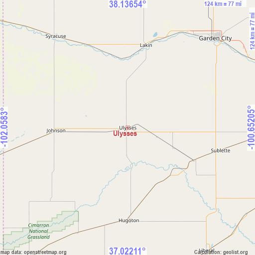
Ulysses GPS coordinates[2]
37° 34' 53.076" North, 101° 21' 18.612" West
| Map corner | latitude | longitude |
|---|---|---|
| Upper-left | 38.13654°, | -102.0583° |
| Center: | 37.58141°, | -101.35517° |
| Lower-right: | 37.02211°, | -100.65205° |
| Map W x H: | 123.9×123.9 km | = 77×77mi |
| max Lat: | 71.29058° ⇑63.7% North |
| Ulysses: | 37.58141° |
| min Lat: | ⇓36.3% South 19.06759° |
| min Long | Ulysses | max Long |
| -171.73463° | -101.35517° | -66.98998° |
| W 18.5%⇐ | ⇒81.5% E |
Elevation
Elevation of Ulysses is 933 m = 3061 ft, and this is 638.2 m = 2094 ft above average elevation for this country.
| Max E: |
3189 m = 10463 ft | 7% |
| Ulysses | 933 m 3061 ft | |
| Avg. | 294.8 m = 967 ft | |
Min E: |
-60 m = -197 ft | 93% |
See also: United States elevation on elevation.city.
Geographical zone
Ulysses is located in North temperate zone (between Tropic of Cancer and the Arctic Circle). Distance of this Northern Tropic circle is 1572.7 km =977.2 mi to South.| Distance of | km | miles | from Ulysses |
|---|---|---|---|
| North Pole | 5828.4 | 3621.6 | to North |
| Arctic Circle | 3222.5 | 2002.4 | to North |
| Tropic Cancer | 1572.7 | 977.2 | to South |
| Equator | 4178.7 | 2596.5 | to South |


Nearby cities:
15 places around Ulysses: (largest is in red/bold)
• Deerfield
48.4 km =30.1 mi,  23°
23°
• Elkhart
79.4 km =49.3 mi,  216°
216°
• Garden City
60.7 km =37.7 mi,  44°
44°
• Holcomb
55.3 km =34.4 mi, 35°
• Hooker
81.2 km =50.5 mi,  171°
171°
• Hugoton
45.2 km =28.1 mi,  179°
179°
• Johnson
34.9 km =21.7 mi,  268°
268°
• Lakin
40.9 km =25.4 mi,  12°
12°
• Liberal
71.1 km =44.2 mi,  147°
147°
• Montezuma
80.4 km =50 mi,  88°
88°
• Plains
76.2 km =47.3 mi,  117°
117°
• Satanta
37.4 km =23.2 mi, 115°
• Sublette
46.4 km =28.8 mi,  103°
103°
• Syracuse
56.6 km =35.2 mi,  321°
321°
• Tyrone
74.3 km =46.2 mi,  159°
159°
Sources, notices
• [Note1] Compared only with cities in United States existing in our database
• [Src1] Map data: © OpenStreetMap contributors (CC-BY-SA)
• [Src2] Other city data from geonames.org with taken over terms of usage.
• [Src3] Geographical zone / Annual Mean Temperature by Robert A. Rohde @ Wikipedia
