Syracuse geodata
Syracuse (Kansas) is a seat of a second-order administrative division; located in United States in America/Denver (GMT-6) time zone. With population of 1,663 people, there are 13035 cities with bigger population in this country. Compared to other cities in United States, 61.7% of cities are located further ↑North; 81.7% of cities are located further →East and 93.3% of cities have lower elevation than Syracuse. Note1


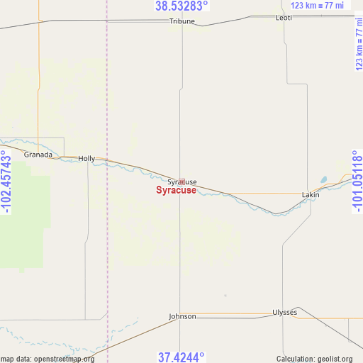
Syracuse GPS coordinates[2]
37° 58' 50.556" North, 101° 45' 15.48" West
| Map corner | latitude | longitude |
|---|---|---|
| Upper-left | 38.53283°, | -102.45743° |
| Center: | 37.98071°, | -101.7543° |
| Lower-right: | 37.4244°, | -101.05118° |
| Map W x H: | 123.2×123.2 km | = 76.6×76.6mi |
| max Lat: | 71.29058° ⇑61.7% North |
| Syracuse: | 37.98071° |
| min Lat: | ⇓38.3% South 19.06759° |
| min Long | Syracuse | max Long |
| -171.73463° | -101.7543° | -66.98998° |
| W 18.3%⇐ | ⇒81.7% E |
Elevation
Elevation of Syracuse is 989 m = 3245 ft, and this is 694.2 m = 2278 ft above average elevation for this country.
| Max E: |
3189 m = 10463 ft | 6.7% |
| Syracuse | 989 m 3245 ft | |
| Avg. | 294.8 m = 967 ft | |
Min E: |
-60 m = -197 ft | 93.3% |
See also: United States elevation on elevation.city.
Geographical zone
Syracuse is located in North temperate zone (between Tropic of Cancer and the Arctic Circle). Distance of this Northern Tropic circle is 1617.1 km =1004.8 mi to South.| Distance of | km | miles | from Syracuse |
|---|---|---|---|
| North Pole | 5784 | 3594 | to North |
| Arctic Circle | 3178.1 | 1974.8 | to North |
| Tropic Cancer | 1617.1 | 1004.8 | to South |
| Equator | 4223.1 | 2624.1 | to South |


Nearby cities:
15 places around Syracuse: (largest is in red/bold)
• Deerfield
54.4 km =33.8 mi,  90°
90°
• Garden City
77.3 km =48 mi, 90°
• Holcomb
67 km =41.6 mi, 89°
• Holly
33.2 km =20.6 mi,  283°
283°
• Hugoton
96.4 km =59.9 mi,  158°
158°
• Johnson
45.6 km =28.3 mi,  179°
179°
• Lakin
44 km =27.3 mi,  95°
95°
• Lamar
76.8 km =47.7 mi, 278°
• Leoti
65.4 km =40.6 mi,  31°
31°
• Satanta
91.6 km =56.9 mi,  131°
131°
• Scott City
92.7 km =57.6 mi,  52°
52°
• Sublette
97.4 km =60.5 mi,  124°
124°
• Tribune
54.4 km =33.8 mi,  0°
0°
• Ulysses
56.6 km =35.2 mi,  141°
141°
• Walsh
80.6 km =50.1 mi,  214°
214°
Sources, notices
• [Note1] Compared only with cities in United States existing in our database
• [Src1] Map data: © OpenStreetMap contributors (CC-BY-SA)
• [Src2] Other city data from geonames.org with taken over terms of usage.
• [Src3] Geographical zone / Annual Mean Temperature by Robert A. Rohde @ Wikipedia
