Flora Vista geodata
Flora Vista (New Mexico) is a populated place; located in United States in America/Denver (GMT-6) time zone. With population of 2,191 people, there are 11369 cities with bigger population in this country. Compared to other cities in United States, 66.9% of cities are located further ↑North; 85.1% of cities are located further →East and 97.8% of cities have lower elevation than Flora Vista. Note1


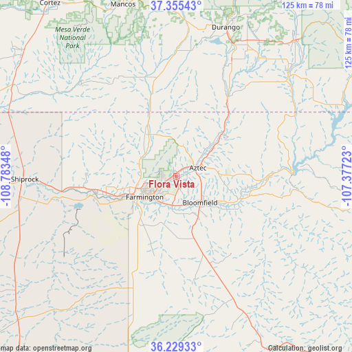
Flora Vista GPS coordinates[2]
36° 47' 40.02" North, 108° 4' 49.26" West
| Map corner | latitude | longitude |
|---|---|---|
| Upper-left | 37.35543°, | -108.78348° |
| Center: | 36.79445°, | -108.08035° |
| Lower-right: | 36.22933°, | -107.37723° |
| Map W x H: | 125.2×125.2 km | = 77.8×77.8mi |
| max Lat: | 71.29058° ⇑66.9% North |
| Flora Vista: | 36.79445° |
| min Lat: | ⇓33.1% South 19.06759° |
| min Long | Flora Vista | max Long |
| -171.73463° | -108.08035° | -66.98998° |
| W 14.9%⇐ | ⇒85.1% E |
Elevation
Elevation of Flora Vista is 1680 m = 5512 ft, and this is 1385.2 m = 4545 ft above average elevation for this country.
| Max E: |
3189 m = 10463 ft | 2.2% |
| Flora Vista | 1680 m 5512 ft | |
| Avg. | 294.8 m = 967 ft | |
Min E: |
-60 m = -197 ft | 97.8% |
See also: United States elevation on elevation.city.
Geographical zone
Flora Vista is located in North temperate zone (between Tropic of Cancer and the Arctic Circle). Distance of this Northern Tropic circle is 1485.2 km =922.9 mi to South.| Distance of | km | miles | from Flora Vista |
|---|---|---|---|
| North Pole | 5915.9 | 3676 | to North |
| Arctic Circle | 3310 | 2056.7 | to North |
| Tropic Cancer | 1485.2 | 922.9 | to South |
| Equator | 4091.2 | 2542.2 | to South |


Nearby cities:
15 places around Flora Vista: (largest is in red/bold)
• Aztec
8.4 km =5.2 mi,  68°
68°
• Bloomfield
12.6 km =7.8 mi,  137°
137°
• Cedar Hill
23.2 km =14.4 mi,  46°
46°
• Farmington
14.4 km =8.9 mi,  239°
239°
• Ignacio
53.4 km =33.2 mi, 48°
• Kirtland
25.8 km =16 mi,  254°
254°
• La Plata
17.8 km =11.1 mi,  326°
326°
• Lee Acres
11.3 km =7 mi,  159°
159°
• Napi Headquarters
20 km =12.4 mi,  217°
217°
• Nenahnezad
30.8 km =19.1 mi,  257°
257°
• Ojo Amarillo
28.1 km =17.5 mi, 246°
• Spencerville
3.5 km =2.2 mi,  34°
34°
• Upper Fruitland
22.6 km =14 mi, 247°
• Waterflow
36 km =22.4 mi, 263°
• West Hammond
12.9 km =8 mi,  167°
167°
Sources, notices
• [Note1] Compared only with cities in United States existing in our database
• [Src1] Map data: © OpenStreetMap contributors (CC-BY-SA)
• [Src2] Other city data from geonames.org with taken over terms of usage.
• [Src3] Geographical zone / Annual Mean Temperature by Robert A. Rohde @ Wikipedia
