Ignacio geodata
Ignacio (Colorado) is a populated place; located in United States in America/Denver (GMT-6) time zone. With population of 720 people, there are 18500 cities with bigger population in this country. Compared to other cities in United States, 65.6% of cities are located further ↑North; 84.9% of cities are located further →East and 99% of cities have lower elevation than Ignacio. Note1


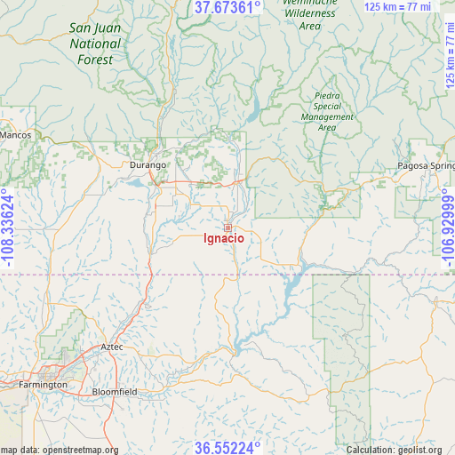
Ignacio GPS coordinates[2]
37° 6' 54" North, 107° 37' 59.196" West
| Map corner | latitude | longitude |
|---|---|---|
| Upper-left | 37.67361°, | -108.33624° |
| Center: | 37.115°, | -107.63311° |
| Lower-right: | 36.55224°, | -106.92999° |
| Map W x H: | 124.7×124.7 km | = 77.5×77.5mi |
| max Lat: | 71.29058° ⇑65.6% North |
| Ignacio: | 37.115° |
| min Lat: | ⇓34.4% South 19.06759° |
| min Long | Ignacio | max Long |
| -171.73463° | -107.63311° | -66.98998° |
| W 15.1%⇐ | ⇒84.9% E |
Elevation
Elevation of Ignacio is 1970 m = 6463 ft, and this is 1675.2 m = 5496 ft above average elevation for this country.
| Max E: |
3189 m = 10463 ft | 1% |
| Ignacio | 1970 m 6463 ft | |
| Avg. | 294.8 m = 967 ft | |
Min E: |
-60 m = -197 ft | 99% |
See also: United States elevation on elevation.city.
Geographical zone
Ignacio is located in North temperate zone (between Tropic of Cancer and the Arctic Circle). Distance of this Northern Tropic circle is 1520.9 km =945 mi to South.| Distance of | km | miles | from Ignacio |
|---|---|---|---|
| North Pole | 5880.3 | 3653.8 | to North |
| Arctic Circle | 3274.4 | 2034.6 | to North |
| Tropic Cancer | 1520.9 | 945 | to South |
| Equator | 4126.8 | 2564.3 | to South |


Nearby cities:
15 places around Ignacio: (largest is in red/bold)
• Aztec
45.6 km =28.3 mi,  224°
224°
• Bayfield
12.7 km =7.9 mi,  14°
14°
• Bloomfield
54.7 km =34 mi,  214°
214°
• Cedar Hill
30.2 km =18.8 mi,  229°
229°
• Dulce
59.8 km =37.2 mi,  109°
109°
• Durango
28.2 km =17.5 mi,  309°
309°
• Farmington
67.5 km =41.9 mi, 230°
• Flora Vista
53.4 km =33.2 mi, 228°
• La Plata
53.6 km =33.3 mi,  247°
247°
• Lee Acres
58.6 km =36.4 mi, 217°
• Mancos
63.5 km =39.5 mi,  293°
293°
• Navajo
54 km =33.6 mi, 110°
• Pagosa Springs
57.8 km =35.9 mi,  72°
72°
• Spencerville
50 km =31.1 mi, 229°
• West Hammond
60.8 km =37.8 mi, 217°
Sources, notices
• [Note1] Compared only with cities in United States existing in our database
• [Src1] Map data: © OpenStreetMap contributors (CC-BY-SA)
• [Src2] Other city data from geonames.org with taken over terms of usage.
• [Src3] Geographical zone / Annual Mean Temperature by Robert A. Rohde @ Wikipedia
