La Cienega geodata
La Cienega (New Mexico) is a populated place; located in United States in America/Denver (GMT-6) time zone. With population of 3,819 people, there are 8439 cities with bigger population in this country. Compared to other cities in United States, 72.4% of cities are located further ↑North; 84.1% of cities are located further →East and 98.4% of cities have lower elevation than La Cienega. Note1


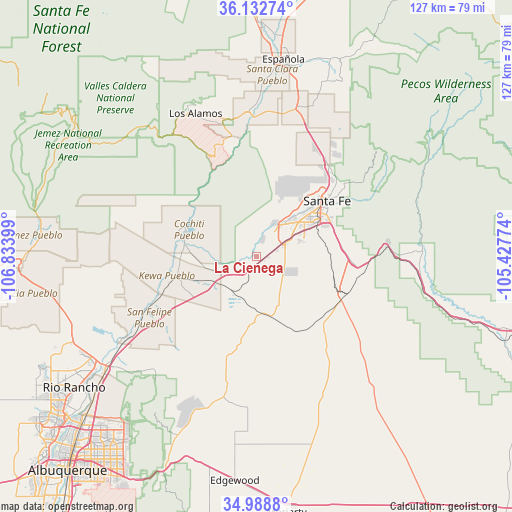
La Cienega GPS coordinates[2]
35° 33' 46.116" North, 106° 7' 51.096" West
| Map corner | latitude | longitude |
|---|---|---|
| Upper-left | 36.13274°, | -106.83399° |
| Center: | 35.56281°, | -106.13086° |
| Lower-right: | 34.9888°, | -105.42774° |
| Map W x H: | 127.2×127.2 km | = 79×79mi |
| max Lat: | 71.29058° ⇑72.4% North |
| La Cienega: | 35.56281° |
| min Lat: | ⇓27.6% South 19.06759° |
| min Long | La Cienega | max Long |
| -171.73463° | -106.13086° | -66.98998° |
| W 15.9%⇐ | ⇒84.1% E |
Elevation
Elevation of La Cienega is 1806 m = 5925 ft, and this is 1511.2 m = 4958 ft above average elevation for this country.
| Max E: |
3189 m = 10463 ft | 1.6% |
| La Cienega | 1806 m 5925 ft | |
| Avg. | 294.8 m = 967 ft | |
Min E: |
-60 m = -197 ft | 98.4% |
See also: United States elevation on elevation.city.
Geographical zone
La Cienega is located in North temperate zone (between Tropic of Cancer and the Arctic Circle). Distance of this Northern Tropic circle is 1348.3 km =837.8 mi to South.| Distance of | km | miles | from La Cienega |
|---|---|---|---|
| North Pole | 6052.8 | 3761 | to North |
| Arctic Circle | 3447 | 2141.9 | to North |
| Tropic Cancer | 1348.3 | 837.8 | to South |
| Equator | 3954.2 | 2457 | to South |


Nearby cities:
15 places around La Cienega: (largest is in red/bold)
• Agua Fria
14.2 km =8.8 mi,  43°
43°
• Algodones
37.5 km =23.3 mi,  237°
237°
• Cochiti
20.5 km =12.7 mi,  284°
284°
• Cochiti Lake
21 km =13 mi,  296°
296°
• El Rancho
36.6 km =22.7 mi,  7°
7°
• Eldorado at Santa Fe
18.2 km =11.3 mi,  102°
102°
• Peña Blanca
18.8 km =11.7 mi,  272°
272°
• Placitas
39 km =24.2 mi,  223°
223°
• Pojoaque
38 km =23.6 mi, 14°
• San Felipe Pueblo
32 km =19.9 mi, 243°
• San Ildefonso Pueblo
36.6 km =22.7 mi,  1°
1°
• Santa Fe
22.3 km =13.9 mi,  51°
51°
• Santo Domingo Pueblo
21.9 km =13.6 mi,  255°
255°
• Tesuque
28.5 km =17.7 mi, 39°
• White Rock
30.2 km =18.8 mi,  347°
347°
Sources, notices
• [Note1] Compared only with cities in United States existing in our database
• [Src1] Map data: © OpenStreetMap contributors (CC-BY-SA)
• [Src2] Other city data from geonames.org with taken over terms of usage.
• [Src3] Geographical zone / Annual Mean Temperature by Robert A. Rohde @ Wikipedia
